You are here: Home > Network List > BK - Berkeley Digital Seismograph Network Stations List
> Station MOD Modoc Plateau, CA > Earthquake Result Viewer
MOD Modoc Plateau, CA - Earthquake Result Viewer
| Earthquake location: |
Southern Peru |
| Earthquake latitude/longitude: |
-15.3/-73.0 |
| Earthquake time(UTC): |
2005/07/26 (207) 14:11:36 GMT |
| Earthquake Depth: |
110 km |
| Earthquake Magnitude: |
5.8 MB, 6.0 MW, 5.9 MW |
| Earthquake Catalog/Contributor: |
WHDF/NEIC |
|
| Network: |
BK Berkeley Digital Seismograph Network |
| Station: |
MOD Modoc Plateau, CA |
| Lat/Lon: |
41.90 N/120.30 W |
| Elevation: |
1554 m |
|
| Distance: |
71.8 deg |
| Az: |
324.687 deg |
| Baz: |
131.663 deg |
| Ray Param: |
0.0538384 |
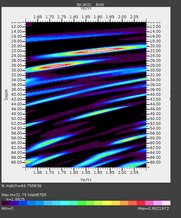
| Estimated Moho Depth: |
21.75 km |
| Estimated Crust Vp/Vs: |
1.89 |
| Assumed Crust Vp: |
6.566 km/s |
| Estimated Crust Vs: |
3.47 km/s |
| Estimated Crust Poisson's Ratio: |
0.31 |
|
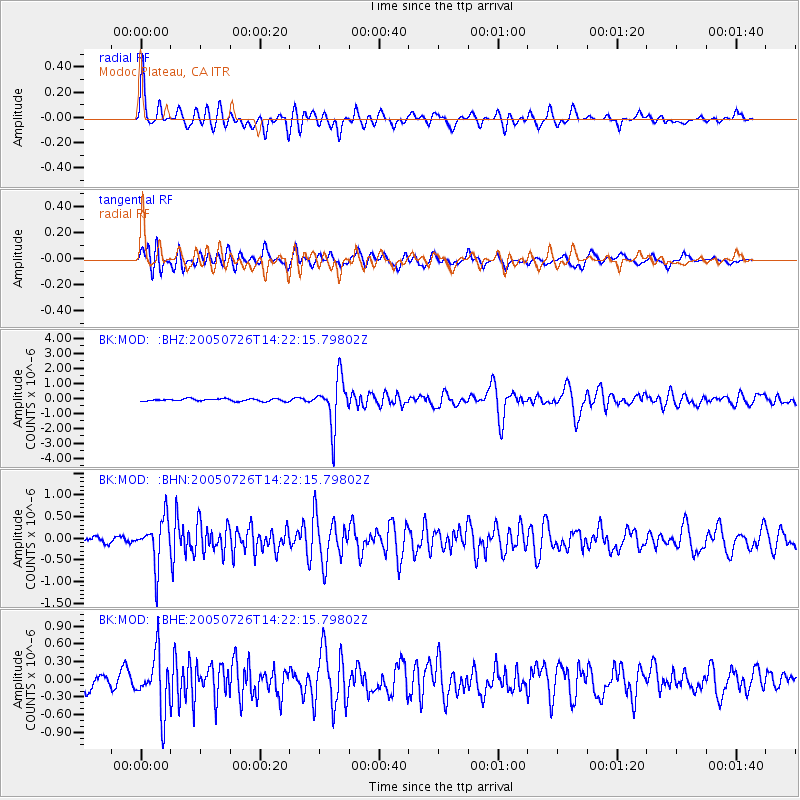
| Radial Match: |
84.755936 % |
| Radial Bump: |
400 |
| Transverse Match: |
79.83822 % |
| Transverse Bump: |
400 |
| SOD ConfigId: |
2475 |
| Insert Time: |
2010-03-05 19:39:58.997 +0000 |
| GWidth: |
2.5 |
| Max Bumps: |
400 |
| Tol: |
0.001 |
|
Signal To Noise
| Channel | StoN | STA | LTA |
| BK:MOD: :BHN:20050726T14:22:15.79802Z | 6.67032 | 5.2243627E-7 | 7.832252E-8 |
| BK:MOD: :BHE:20050726T14:22:15.79802Z | 4.1590714 | 4.776882E-7 | 1.1485453E-7 |
| BK:MOD: :BHZ:20050726T14:22:15.79802Z | 19.563965 | 1.5929329E-6 | 8.142178E-8 |
| Arrivals |
| Ps | 3.1 SECOND |
| PpPs | 9.3 SECOND |
| PsPs/PpSs | 12 SECOND |


