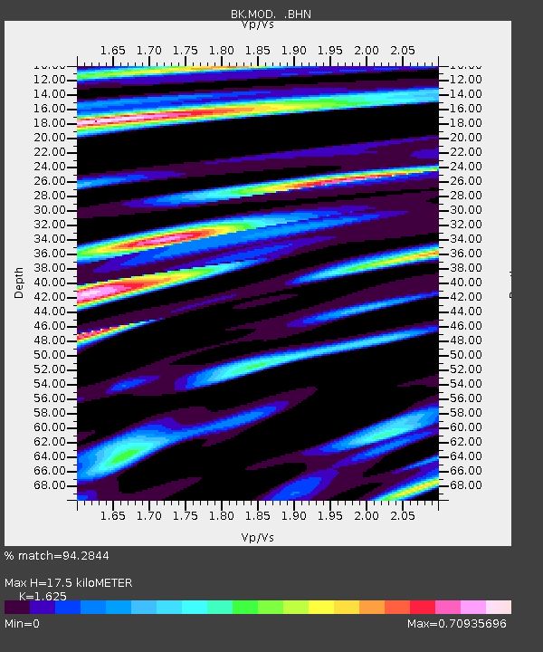
MOD Modoc Plateau, CA - Earthquake Result Viewer
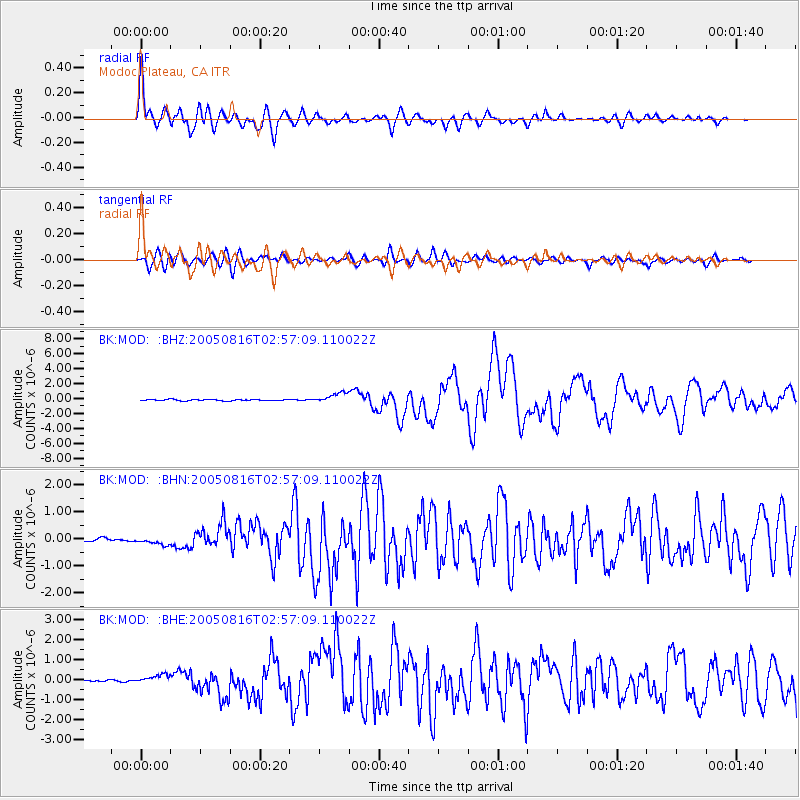
Earthquake location: Near East Coast Of Honshu, Japan
Earthquake latitude/longitude: 38.3/142.0
Earthquake time(UTC): 2005/08/16 (228) 02:46:28 GMT
Earthquake Depth: 36 km
Earthquake Magnitude: 6.5 MB, 6.8 MS, 7.2 MW, 7.1 MW
Earthquake Catalog/Contributor: WHDF/NEIC
Network: BK Berkeley Digital Seismograph Network
Station: MOD Modoc Plateau, CA
Lat/Lon: 41.90 N/120.30 W
Elevation: 1554 m
Distance: 70.6 deg
Az: 51.664 deg
Baz: 304.209 deg
Ray Param: 0.054818224
Estimated Moho Depth: 17.5 km
Estimated Crust Vp/Vs: 1.62
Assumed Crust Vp: 6.566 km/s
Estimated Crust Vs: 4.041 km/s
Estimated Crust Poisson's Ratio: 0.20
Radial Match: 94.2844 %
Radial Bump: 400
Transverse Match: 86.44326 %
Transverse Bump: 400
SOD ConfigId: 2475
Insert Time: 2010-03-05 19:40:02.780 +0000
GWidth: 2.5
Max Bumps: 400
Tol: 0.001

Signal To Noise

ChannelStoNSTALTA
BK:MOD: :BHN:20050816T02:57:09.110022Z2.37745171.4057541E-75.9128606E-8
BK:MOD: :BHE:20050816T02:57:09.110022Z3.4145782.1138133E-76.190555E-8
BK:MOD: :BHZ:20050816T02:57:09.110022Z8.61496.966966E-78.087112E-8
Arrivals
Ps1.7 SECOND
PpPs6.7 SECOND
PsPs/PpSs8.4 SECOND