You are here: Home > Network List > BK - Berkeley Digital Seismograph Network Stations List
> Station MOD Modoc Plateau, CA > Earthquake Result Viewer
MOD Modoc Plateau, CA - Earthquake Result Viewer
| Earthquake location: |
Peru-Ecuador Border Region |
| Earthquake latitude/longitude: |
-2.3/-77.8 |
| Earthquake time(UTC): |
2007/11/16 (320) 03:13:00 GMT |
| Earthquake Depth: |
123 km |
| Earthquake Magnitude: |
6.3 MB, 6.8 MW, 6.7 MW |
| Earthquake Catalog/Contributor: |
WHDF/NEIC |
|
| Network: |
BK Berkeley Digital Seismograph Network |
| Station: |
MOD Modoc Plateau, CA |
| Lat/Lon: |
41.90 N/120.30 W |
| Elevation: |
1554 m |
|
| Distance: |
58.4 deg |
| Az: |
323.732 deg |
| Baz: |
127.645 deg |
| Ray Param: |
0.06248078 |
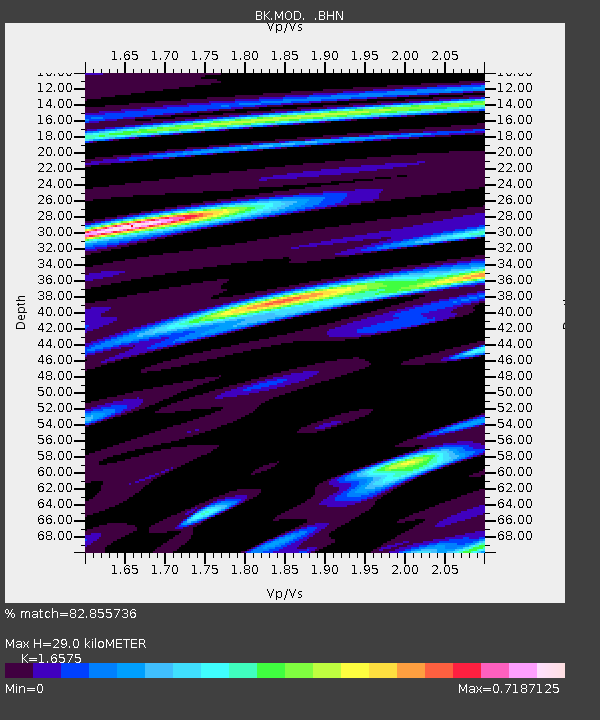
| Estimated Moho Depth: |
29.0 km |
| Estimated Crust Vp/Vs: |
1.66 |
| Assumed Crust Vp: |
6.566 km/s |
| Estimated Crust Vs: |
3.961 km/s |
| Estimated Crust Poisson's Ratio: |
0.21 |
|
| Radial Match: |
82.855736 % |
| Radial Bump: |
400 |
| Transverse Match: |
74.57052 % |
| Transverse Bump: |
400 |
| SOD ConfigId: |
2564 |
| Insert Time: |
2010-03-05 19:40:19.021 +0000 |
| GWidth: |
2.5 |
| Max Bumps: |
400 |
| Tol: |
0.001 |
|
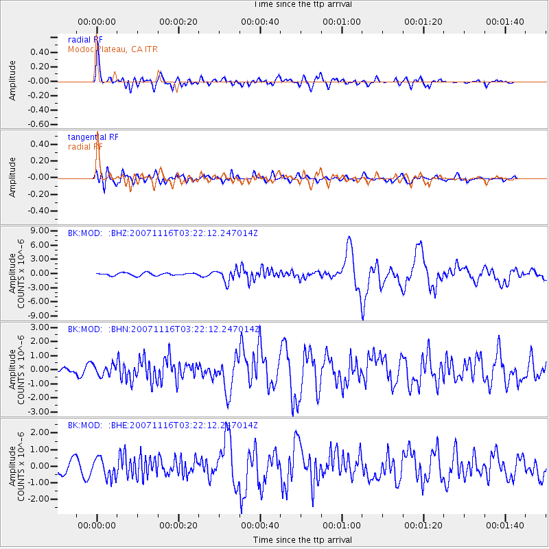
Signal To Noise
| Channel | StoN | STA | LTA |
| BK:MOD: :BHN:20071116T03:22:12.247014Z | 1.6502994 | 3.6434204E-7 | 2.2077329E-7 |
| BK:MOD: :BHE:20071116T03:22:12.247014Z | 1.7730259 | 5.9061483E-7 | 3.3311125E-7 |
| BK:MOD: :BHZ:20071116T03:22:12.247014Z | 4.6919284 | 1.3298522E-6 | 2.8343402E-7 |
| Arrivals |
| Ps | 3.1 SECOND |
| PpPs | 11 SECOND |
| PsPs/PpSs | 14 SECOND |


