You are here: Home > Network List > CI - Caltech Regional Seismic Network Stations List
> Station MPM Manuel Prospect Mine, California, USA > Earthquake Result Viewer
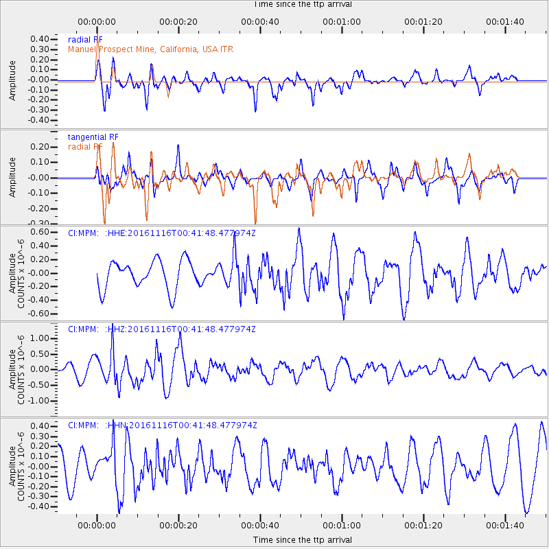
MPM Manuel Prospect Mine, California, USA - Earthquake Result Viewer
*The percent match for this event was below the threshold and hence no stack was calculated.
| Earthquake location: |
Tonga Islands Region |
| Earthquake latitude/longitude: |
-20.2/-173.0 |
| Earthquake time(UTC): |
2016/11/16 (321) 00:30:28 GMT |
| Earthquake Depth: |
10 km |
| Earthquake Magnitude: |
5.9 MB, 5.6 MWB |
| Earthquake Catalog/Contributor: |
NEIC PDE/NEIC COMCAT |
|
| Network: |
CI Caltech Regional Seismic Network |
| Station: |
MPM Manuel Prospect Mine, California, USA |
| Lat/Lon: |
36.06 N/117.49 W |
| Elevation: |
185 m |
|
| Distance: |
76.7 deg |
| Az: |
43.315 deg |
| Baz: |
232.674 deg |
| Ray Param: |
$rayparam |
*The percent match for this event was below the threshold and hence was not used in the summary stack. |
|
| Radial Match: |
70.79662 % |
| Radial Bump: |
400 |
| Transverse Match: |
52.594265 % |
| Transverse Bump: |
350 |
| SOD ConfigId: |
11737051 |
| Insert Time: |
2019-04-26 02:16:29.095 +0000 |
| GWidth: |
2.5 |
| Max Bumps: |
400 |
| Tol: |
0.001 |
|
Signal To Noise
| Channel | StoN | STA | LTA |
| CI:MPM: :HHZ:20161116T00:41:48.477974Z | 3.4440205 | 4.948709E-7 | 1.4368987E-7 |
| CI:MPM: :HHN:20161116T00:41:48.477974Z | 0.82180995 | 1.6008349E-7 | 1.947938E-7 |
| CI:MPM: :HHE:20161116T00:41:48.477974Z | 1.0109348 | 2.1060954E-7 | 2.0833147E-7 |
| Arrivals |
| Ps | |
| PpPs | |
| PsPs/PpSs | |


