You are here: Home > Network List > CI - Caltech Regional Seismic Network Stations List
> Station MPP McPhearson Peak > Earthquake Result Viewer
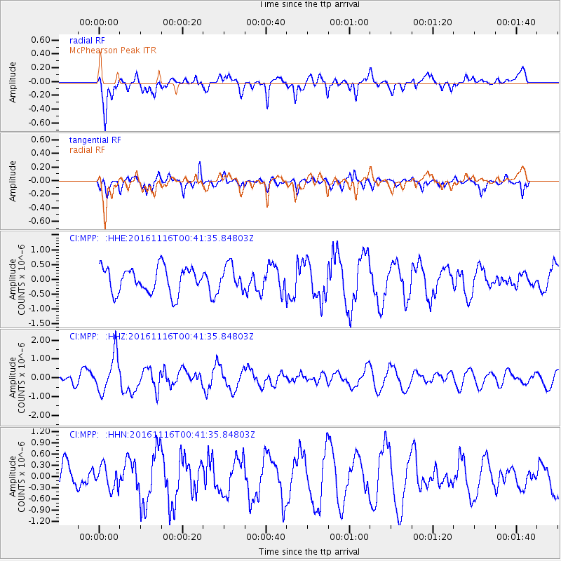
MPP McPhearson Peak - Earthquake Result Viewer
*The percent match for this event was below the threshold and hence no stack was calculated.
| Earthquake location: |
Tonga Islands Region |
| Earthquake latitude/longitude: |
-20.2/-173.0 |
| Earthquake time(UTC): |
2016/11/16 (321) 00:30:28 GMT |
| Earthquake Depth: |
10 km |
| Earthquake Magnitude: |
5.9 MB, 5.6 MWB |
| Earthquake Catalog/Contributor: |
NEIC PDE/NEIC COMCAT |
|
| Network: |
CI Caltech Regional Seismic Network |
| Station: |
MPP McPhearson Peak |
| Lat/Lon: |
34.89 N/119.81 W |
| Elevation: |
1739 m |
|
| Distance: |
74.5 deg |
| Az: |
43.057 deg |
| Baz: |
231.266 deg |
| Ray Param: |
$rayparam |
*The percent match for this event was below the threshold and hence was not used in the summary stack. |
|
| Radial Match: |
59.656338 % |
| Radial Bump: |
400 |
| Transverse Match: |
60.569244 % |
| Transverse Bump: |
400 |
| SOD ConfigId: |
11737051 |
| Insert Time: |
2019-04-26 02:16:29.747 +0000 |
| GWidth: |
2.5 |
| Max Bumps: |
400 |
| Tol: |
0.001 |
|
Signal To Noise
| Channel | StoN | STA | LTA |
| CI:MPP: :HHZ:20161116T00:41:35.84803Z | 3.8440742 | 1.0208648E-6 | 2.6556847E-7 |
| CI:MPP: :HHN:20161116T00:41:35.84803Z | 0.8751603 | 3.0831268E-7 | 3.522928E-7 |
| CI:MPP: :HHE:20161116T00:41:35.84803Z | 0.9455364 | 4.0884427E-7 | 4.3239405E-7 |
| Arrivals |
| Ps | |
| PpPs | |
| PsPs/PpSs | |


