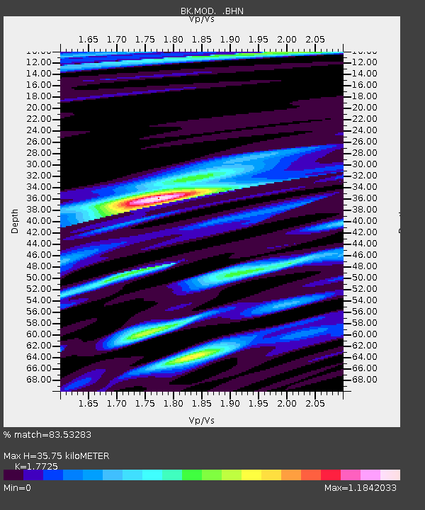
MOD Modoc Plateau, CA - Earthquake Result Viewer
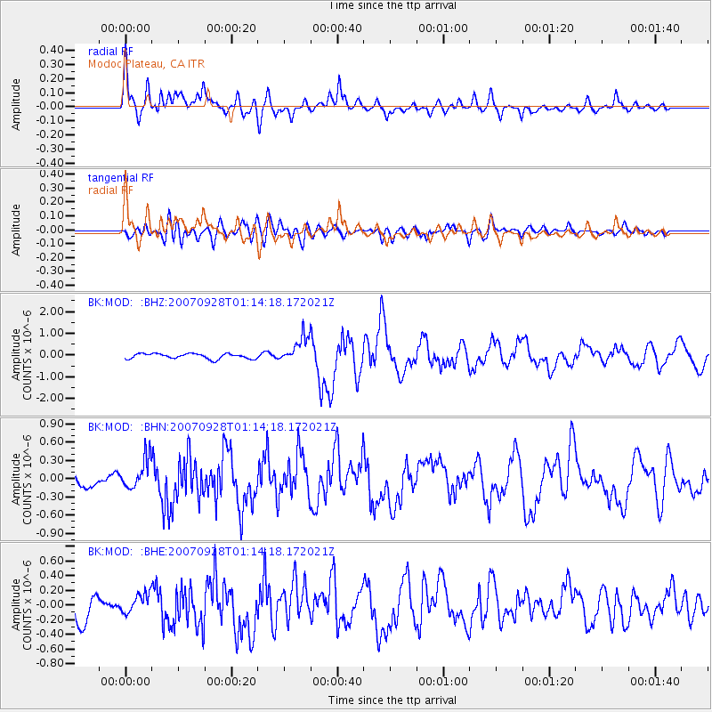
Earthquake location: Southeast Of Loyalty Islands
Earthquake latitude/longitude: -21.2/169.4
Earthquake time(UTC): 2007/09/28 (271) 01:01:48 GMT
Earthquake Depth: 10 km
Earthquake Magnitude: 5.8 MB, 6.4 MS, 6.3 MW, 6.2 MW
Earthquake Catalog/Contributor: WHDF/NEIC
Network: BK Berkeley Digital Seismograph Network
Station: MOD Modoc Plateau, CA
Lat/Lon: 41.90 N/120.30 W
Elevation: 1554 m
Distance: 90.3 deg
Az: 44.667 deg
Baz: 241.486 deg
Ray Param: 0.04168471
Estimated Moho Depth: 35.75 km
Estimated Crust Vp/Vs: 1.77
Assumed Crust Vp: 6.566 km/s
Estimated Crust Vs: 3.704 km/s
Estimated Crust Poisson's Ratio: 0.27
Radial Match: 83.53283 %
Radial Bump: 400
Transverse Match: 69.54855 %
Transverse Bump: 400
SOD ConfigId: 2564
Insert Time: 2010-03-05 19:40:31.512 +0000
GWidth: 2.5
Max Bumps: 400
Tol: 0.001

Signal To Noise

ChannelStoNSTALTA
BK:MOD: :BHN:20070928T01:14:18.172021Z1.2586832.5420664E-72.0196241E-7
BK:MOD: :BHE:20070928T01:14:18.172021Z0.817187251.3191914E-71.6143073E-7
BK:MOD: :BHZ:20070928T01:14:18.172021Z5.2534816.2433764E-71.1884266E-7
Arrivals
Ps4.3 SECOND
PpPs15 SECOND
PsPs/PpSs19 SECOND