You are here: Home > Network List > BK - Berkeley Digital Seismograph Network Stations List
> Station MOD Modoc Plateau, CA > Earthquake Result Viewer
MOD Modoc Plateau, CA - Earthquake Result Viewer
| Earthquake location: |
Tonga Islands Region |
| Earthquake latitude/longitude: |
-17.3/-172.3 |
| Earthquake time(UTC): |
2007/08/27 (239) 17:11:59 GMT |
| Earthquake Depth: |
10 km |
| Earthquake Magnitude: |
5.6 MB, 5.5 MS, 5.7 MW |
| Earthquake Catalog/Contributor: |
WHDF/NEIC |
|
| Network: |
BK Berkeley Digital Seismograph Network |
| Station: |
MOD Modoc Plateau, CA |
| Lat/Lon: |
41.90 N/120.30 W |
| Elevation: |
1554 m |
|
| Distance: |
75.9 deg |
| Az: |
37.301 deg |
| Baz: |
230.85 deg |
| Ray Param: |
0.051324155 |
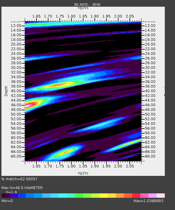
| Estimated Moho Depth: |
46.5 km |
| Estimated Crust Vp/Vs: |
1.60 |
| Assumed Crust Vp: |
6.566 km/s |
| Estimated Crust Vs: |
4.104 km/s |
| Estimated Crust Poisson's Ratio: |
0.18 |
|
| Radial Match: |
82.59057 % |
| Radial Bump: |
400 |
| Transverse Match: |
54.46216 % |
| Transverse Bump: |
400 |
| SOD ConfigId: |
2564 |
| Insert Time: |
2010-03-05 19:40:40.584 +0000 |
| GWidth: |
2.5 |
| Max Bumps: |
400 |
| Tol: |
0.001 |
|
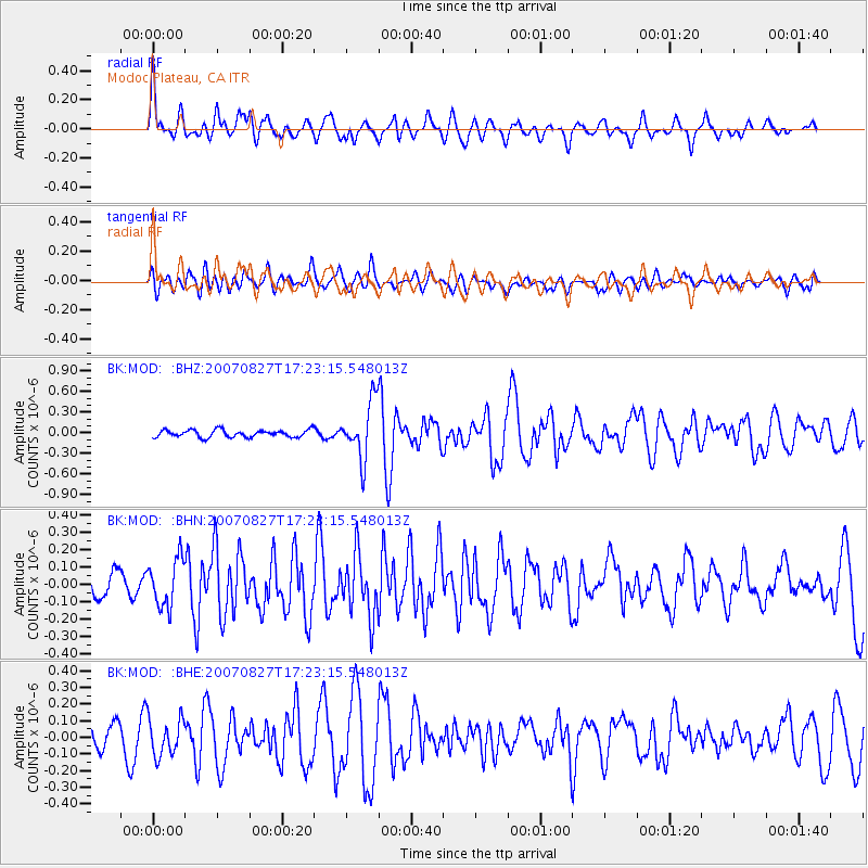
Signal To Noise
| Channel | StoN | STA | LTA |
| BK:MOD: :BHN:20070827T17:23:15.548013Z | 1.655597 | 1.3707437E-7 | 8.279453E-8 |
| BK:MOD: :BHE:20070827T17:23:15.548013Z | 1.4136027 | 1.11723885E-7 | 7.9034855E-8 |
| BK:MOD: :BHZ:20070827T17:23:15.548013Z | 7.7625523 | 4.118981E-7 | 5.30622E-8 |
| Arrivals |
| Ps | 4.4 SECOND |
| PpPs | 18 SECOND |
| PsPs/PpSs | 22 SECOND |


