You are here: Home > Network List > BK - Berkeley Digital Seismograph Network Stations List
> Station MOD Modoc Plateau, CA > Earthquake Result Viewer
MOD Modoc Plateau, CA - Earthquake Result Viewer
| Earthquake location: |
Fiji Islands Region |
| Earthquake latitude/longitude: |
-18.0/-179.6 |
| Earthquake time(UTC): |
2006/02/24 (055) 14:15:45 GMT |
| Earthquake Depth: |
622 km |
| Earthquake Magnitude: |
5.9 MB, 6.1 MW, 6.0 MW |
| Earthquake Catalog/Contributor: |
WHDF/NEIC |
|
| Network: |
BK Berkeley Digital Seismograph Network |
| Station: |
MOD Modoc Plateau, CA |
| Lat/Lon: |
41.90 N/120.30 W |
| Elevation: |
1554 m |
|
| Distance: |
80.9 deg |
| Az: |
40.543 deg |
| Baz: |
235.964 deg |
| Ray Param: |
0.04604312 |
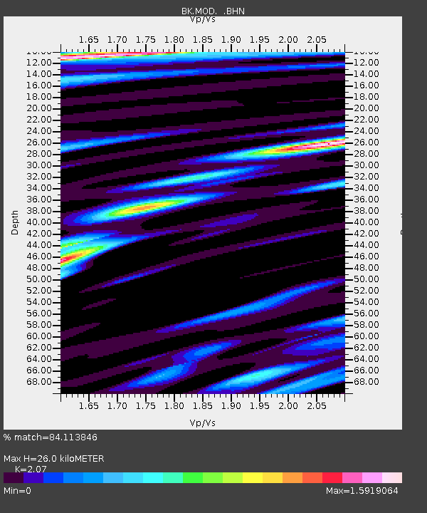
| Estimated Moho Depth: |
26.0 km |
| Estimated Crust Vp/Vs: |
2.07 |
| Assumed Crust Vp: |
6.566 km/s |
| Estimated Crust Vs: |
3.172 km/s |
| Estimated Crust Poisson's Ratio: |
0.35 |
|
| Radial Match: |
84.113846 % |
| Radial Bump: |
400 |
| Transverse Match: |
86.24017 % |
| Transverse Bump: |
400 |
| SOD ConfigId: |
2422 |
| Insert Time: |
2010-03-05 19:41:04.957 +0000 |
| GWidth: |
2.5 |
| Max Bumps: |
400 |
| Tol: |
0.001 |
|
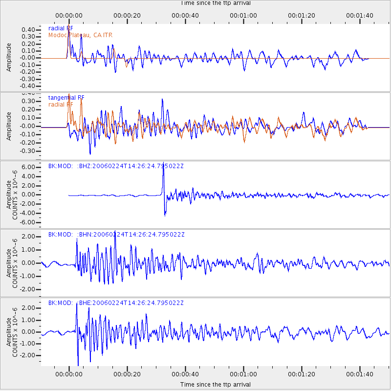
Signal To Noise
| Channel | StoN | STA | LTA |
| BK:MOD: :BHN:20060224T14:26:24.795022Z | 5.665684 | 5.047558E-7 | 8.9089994E-8 |
| BK:MOD: :BHE:20060224T14:26:24.795022Z | 5.8650594 | 8.0029474E-7 | 1.3645126E-7 |
| BK:MOD: :BHZ:20060224T14:26:24.795022Z | 25.546421 | 2.1812982E-6 | 8.5385665E-8 |
| Arrivals |
| Ps | 4.3 SECOND |
| PpPs | 12 SECOND |
| PsPs/PpSs | 16 SECOND |


