You are here: Home > Network List > TA - USArray Transportable Network (new EarthScope stations) Stations List
> Station 435B Jarrell, TX, USA > Earthquake Result Viewer
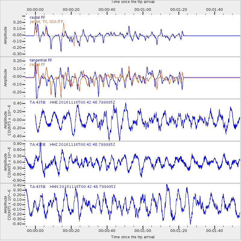
435B Jarrell, TX, USA - Earthquake Result Viewer
*The percent match for this event was below the threshold and hence no stack was calculated.
| Earthquake location: |
Tonga Islands Region |
| Earthquake latitude/longitude: |
-20.2/-173.0 |
| Earthquake time(UTC): |
2016/11/16 (321) 00:30:28 GMT |
| Earthquake Depth: |
10 km |
| Earthquake Magnitude: |
5.9 MB, 5.6 MWB |
| Earthquake Catalog/Contributor: |
NEIC PDE/NEIC COMCAT |
|
| Network: |
TA USArray Transportable Network (new EarthScope stations) |
| Station: |
435B Jarrell, TX, USA |
| Lat/Lon: |
30.78 N/97.58 W |
| Elevation: |
248 m |
|
| Distance: |
88.3 deg |
| Az: |
56.419 deg |
| Baz: |
245.4 deg |
| Ray Param: |
$rayparam |
*The percent match for this event was below the threshold and hence was not used in the summary stack. |
|
| Radial Match: |
49.080982 % |
| Radial Bump: |
344 |
| Transverse Match: |
47.700233 % |
| Transverse Bump: |
400 |
| SOD ConfigId: |
11737051 |
| Insert Time: |
2019-04-26 02:20:27.523 +0000 |
| GWidth: |
2.5 |
| Max Bumps: |
400 |
| Tol: |
0.001 |
|
Signal To Noise
| Channel | StoN | STA | LTA |
| TA:435B: :HHZ:20161116T00:42:48.799995Z | 2.4944348 | 3.7525444E-7 | 1.5043666E-7 |
| TA:435B: :HHN:20161116T00:42:48.799995Z | 0.6797633 | 1.0259531E-7 | 1.5092799E-7 |
| TA:435B: :HHE:20161116T00:42:48.799995Z | 0.55701524 | 9.5234526E-8 | 1.7097292E-7 |
| Arrivals |
| Ps | |
| PpPs | |
| PsPs/PpSs | |


