You are here: Home > Network List > BK - Berkeley Digital Seismograph Network Stations List
> Station MOD Modoc Plateau, CA > Earthquake Result Viewer
MOD Modoc Plateau, CA - Earthquake Result Viewer
| Earthquake location: |
Kuril Islands |
| Earthquake latitude/longitude: |
46.9/153.7 |
| Earthquake time(UTC): |
2006/11/15 (319) 11:33:23 GMT |
| Earthquake Depth: |
10 km |
| Earthquake Magnitude: |
5.5 MB |
| Earthquake Catalog/Contributor: |
WHDF/NEIC |
|
| Network: |
BK Berkeley Digital Seismograph Network |
| Station: |
MOD Modoc Plateau, CA |
| Lat/Lon: |
41.90 N/120.30 W |
| Elevation: |
1554 m |
|
| Distance: |
58.7 deg |
| Az: |
60.671 deg |
| Baz: |
306.737 deg |
| Ray Param: |
0.06269639 |
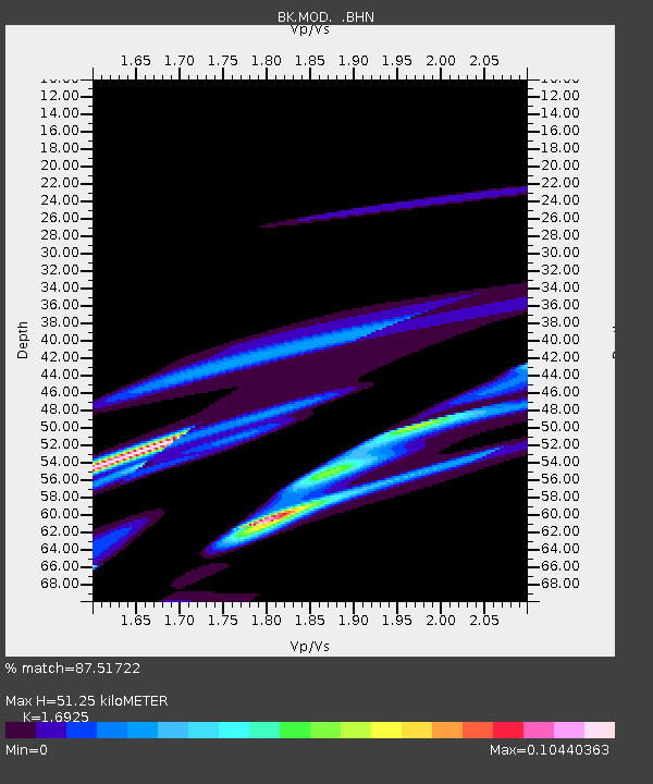
| Estimated Moho Depth: |
51.25 km |
| Estimated Crust Vp/Vs: |
1.69 |
| Assumed Crust Vp: |
6.566 km/s |
| Estimated Crust Vs: |
3.88 km/s |
| Estimated Crust Poisson's Ratio: |
0.23 |
|
| Radial Match: |
87.51722 % |
| Radial Bump: |
400 |
| Transverse Match: |
33.84065 % |
| Transverse Bump: |
178 |
| SOD ConfigId: |
2564 |
| Insert Time: |
2010-03-05 19:41:11.504 +0000 |
| GWidth: |
2.5 |
| Max Bumps: |
400 |
| Tol: |
0.001 |
|
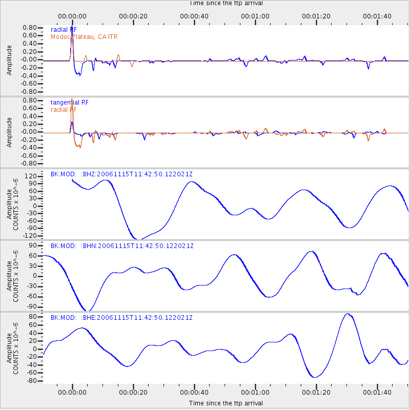
Signal To Noise
| Channel | StoN | STA | LTA |
| BK:MOD: :BHN:20061115T11:42:50.122021Z | 1.9878091 | 8.570367E-5 | 4.311464E-5 |
| BK:MOD: :BHE:20061115T11:42:50.122021Z | 2.5558834 | 7.3293646E-5 | 2.8676444E-5 |
| BK:MOD: :BHZ:20061115T11:42:50.122021Z | 0.73360807 | 6.8080946E-5 | 9.280289E-5 |
| Arrivals |
| Ps | 5.7 SECOND |
| PpPs | 20 SECOND |
| PsPs/PpSs | 26 SECOND |


