You are here: Home > Network List > BK - Berkeley Digital Seismograph Network Stations List
> Station MOD Modoc Plateau, CA > Earthquake Result Viewer
MOD Modoc Plateau, CA - Earthquake Result Viewer
| Earthquake location: |
Kuril Islands |
| Earthquake latitude/longitude: |
46.6/153.3 |
| Earthquake time(UTC): |
2006/11/15 (319) 11:14:13 GMT |
| Earthquake Depth: |
10 km |
| Earthquake Magnitude: |
6.5 MB, 7.8 MS, 8.3 MW, 7.9 MW |
| Earthquake Catalog/Contributor: |
WHDF/NEIC |
|
| Network: |
BK Berkeley Digital Seismograph Network |
| Station: |
MOD Modoc Plateau, CA |
| Lat/Lon: |
41.90 N/120.30 W |
| Elevation: |
1554 m |
|
| Distance: |
59.1 deg |
| Az: |
60.287 deg |
| Baz: |
306.647 deg |
| Ray Param: |
0.062427618 |
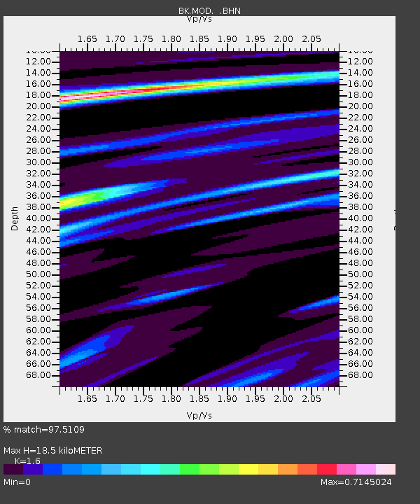
| Estimated Moho Depth: |
18.5 km |
| Estimated Crust Vp/Vs: |
1.60 |
| Assumed Crust Vp: |
6.566 km/s |
| Estimated Crust Vs: |
4.104 km/s |
| Estimated Crust Poisson's Ratio: |
0.18 |
|
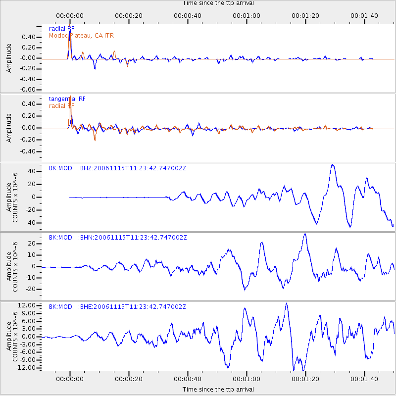
| Radial Match: |
97.5109 % |
| Radial Bump: |
263 |
| Transverse Match: |
93.7838 % |
| Transverse Bump: |
400 |
| SOD ConfigId: |
2564 |
| Insert Time: |
2010-03-05 19:41:13.265 +0000 |
| GWidth: |
2.5 |
| Max Bumps: |
400 |
| Tol: |
0.001 |
|
Signal To Noise
| Channel | StoN | STA | LTA |
| BK:MOD: :BHN:20061115T11:23:42.747002Z | 1.658978 | 3.6850093E-7 | 2.2212527E-7 |
| BK:MOD: :BHE:20061115T11:23:42.747002Z | 2.6650405 | 5.6554137E-7 | 2.1220744E-7 |
| BK:MOD: :BHZ:20061115T11:23:42.747002Z | 5.2177978 | 1.4603338E-6 | 2.798755E-7 |
| Arrivals |
| Ps | 1.8 SECOND |
| PpPs | 6.9 SECOND |
| PsPs/PpSs | 8.7 SECOND |


