You are here: Home > Network List > TA - USArray Transportable Network (new EarthScope stations) Stations List
> Station I23K Minto, Yukon-Koyukuk, AK, USA > Earthquake Result Viewer
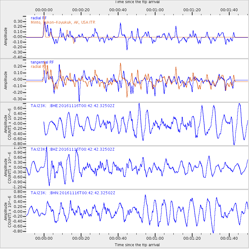
I23K Minto, Yukon-Koyukuk, AK, USA - Earthquake Result Viewer
*The percent match for this event was below the threshold and hence no stack was calculated.
| Earthquake location: |
Tonga Islands Region |
| Earthquake latitude/longitude: |
-20.2/-173.0 |
| Earthquake time(UTC): |
2016/11/16 (321) 00:30:28 GMT |
| Earthquake Depth: |
10 km |
| Earthquake Magnitude: |
5.9 MB, 5.6 MWB |
| Earthquake Catalog/Contributor: |
NEIC PDE/NEIC COMCAT |
|
| Network: |
TA USArray Transportable Network (new EarthScope stations) |
| Station: |
I23K Minto, Yukon-Koyukuk, AK, USA |
| Lat/Lon: |
65.15 N/149.36 W |
| Elevation: |
149 m |
|
| Distance: |
87.0 deg |
| Az: |
9.755 deg |
| Baz: |
202.123 deg |
| Ray Param: |
$rayparam |
*The percent match for this event was below the threshold and hence was not used in the summary stack. |
|
| Radial Match: |
57.16467 % |
| Radial Bump: |
400 |
| Transverse Match: |
58.063168 % |
| Transverse Bump: |
346 |
| SOD ConfigId: |
11737051 |
| Insert Time: |
2019-04-26 02:20:46.230 +0000 |
| GWidth: |
2.5 |
| Max Bumps: |
400 |
| Tol: |
0.001 |
|
Signal To Noise
| Channel | StoN | STA | LTA |
| TA:I23K: :BHZ:20161116T00:42:42.32502Z | 2.3845954 | 5.931256E-7 | 2.4873216E-7 |
| TA:I23K: :BHN:20161116T00:42:42.32502Z | 0.8821098 | 1.9113514E-7 | 2.1667952E-7 |
| TA:I23K: :BHE:20161116T00:42:42.32502Z | 0.6807122 | 1.6770406E-7 | 2.4636557E-7 |
| Arrivals |
| Ps | |
| PpPs | |
| PsPs/PpSs | |


