You are here: Home > Network List > BK - Berkeley Digital Seismograph Network Stations List
> Station MOD Modoc Plateau, CA > Earthquake Result Viewer
MOD Modoc Plateau, CA - Earthquake Result Viewer
| Earthquake location: |
Mariana Islands Region |
| Earthquake latitude/longitude: |
19.6/146.8 |
| Earthquake time(UTC): |
2004/07/20 (202) 14:16:23 GMT |
| Earthquake Depth: |
13 km |
| Earthquake Magnitude: |
5.7 MB, 5.6 MS, 5.9 MW, 5.9 MW |
| Earthquake Catalog/Contributor: |
WHDF/NEIC |
|
| Network: |
BK Berkeley Digital Seismograph Network |
| Station: |
MOD Modoc Plateau, CA |
| Lat/Lon: |
41.90 N/120.30 W |
| Elevation: |
1554 m |
|
| Distance: |
79.2 deg |
| Az: |
49.369 deg |
| Baz: |
286.622 deg |
| Ray Param: |
0.049095884 |
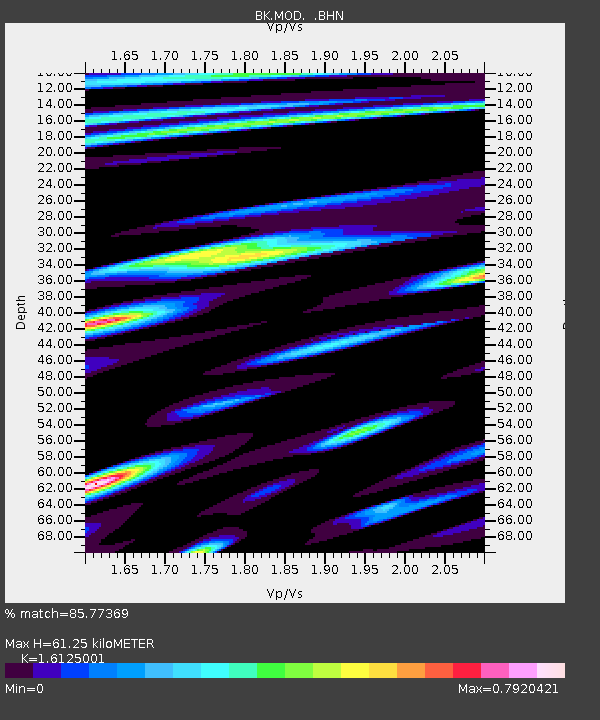
| Estimated Moho Depth: |
61.25 km |
| Estimated Crust Vp/Vs: |
1.61 |
| Assumed Crust Vp: |
6.566 km/s |
| Estimated Crust Vs: |
4.072 km/s |
| Estimated Crust Poisson's Ratio: |
0.19 |
|
| Radial Match: |
85.77369 % |
| Radial Bump: |
400 |
| Transverse Match: |
75.70679 % |
| Transverse Bump: |
400 |
| SOD ConfigId: |
124340 |
| Insert Time: |
2010-03-05 19:41:21.256 +0000 |
| GWidth: |
2.5 |
| Max Bumps: |
400 |
| Tol: |
0.001 |
|
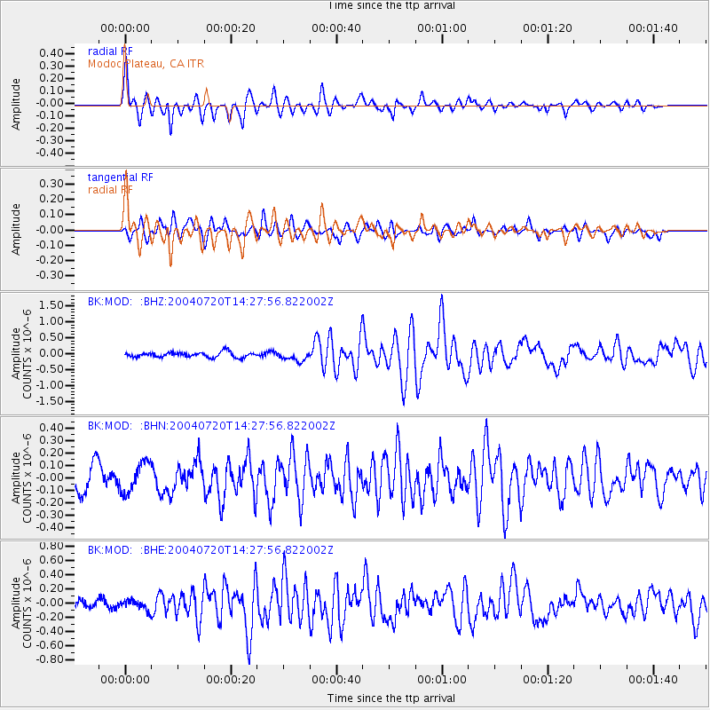
Signal To Noise
| Channel | StoN | STA | LTA |
| BK:MOD: :BHN:20040720T14:27:56.822002Z | 1.4346828 | 1.2143761E-7 | 8.464422E-8 |
| BK:MOD: :BHE:20040720T14:27:56.822002Z | 1.0239782 | 6.812222E-8 | 6.6527015E-8 |
| BK:MOD: :BHZ:20040720T14:27:56.822002Z | 1.8380837 | 1.4945124E-7 | 8.130818E-8 |
| Arrivals |
| Ps | 5.9 SECOND |
| PpPs | 24 SECOND |
| PsPs/PpSs | 29 SECOND |


