You are here: Home > Network List > BK - Berkeley Digital Seismograph Network Stations List
> Station MOD Modoc Plateau, CA > Earthquake Result Viewer
MOD Modoc Plateau, CA - Earthquake Result Viewer
| Earthquake location: |
Santa Cruz Islands |
| Earthquake latitude/longitude: |
-10.9/166.3 |
| Earthquake time(UTC): |
2004/06/22 (174) 09:04:43 GMT |
| Earthquake Depth: |
153 km |
| Earthquake Magnitude: |
5.8 MB, 5.9 MW, 5.8 MW |
| Earthquake Catalog/Contributor: |
WHDF/NEIC |
|
| Network: |
BK Berkeley Digital Seismograph Network |
| Station: |
MOD Modoc Plateau, CA |
| Lat/Lon: |
41.90 N/120.30 W |
| Elevation: |
1554 m |
|
| Distance: |
85.2 deg |
| Az: |
45.896 deg |
| Baz: |
250.869 deg |
| Ray Param: |
0.044598088 |
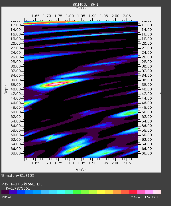
| Estimated Moho Depth: |
37.5 km |
| Estimated Crust Vp/Vs: |
1.74 |
| Assumed Crust Vp: |
6.566 km/s |
| Estimated Crust Vs: |
3.779 km/s |
| Estimated Crust Poisson's Ratio: |
0.25 |
|
| Radial Match: |
81.8135 % |
| Radial Bump: |
400 |
| Transverse Match: |
76.36968 % |
| Transverse Bump: |
400 |
| SOD ConfigId: |
124340 |
| Insert Time: |
2010-03-05 19:41:23.085 +0000 |
| GWidth: |
2.5 |
| Max Bumps: |
400 |
| Tol: |
0.001 |
|
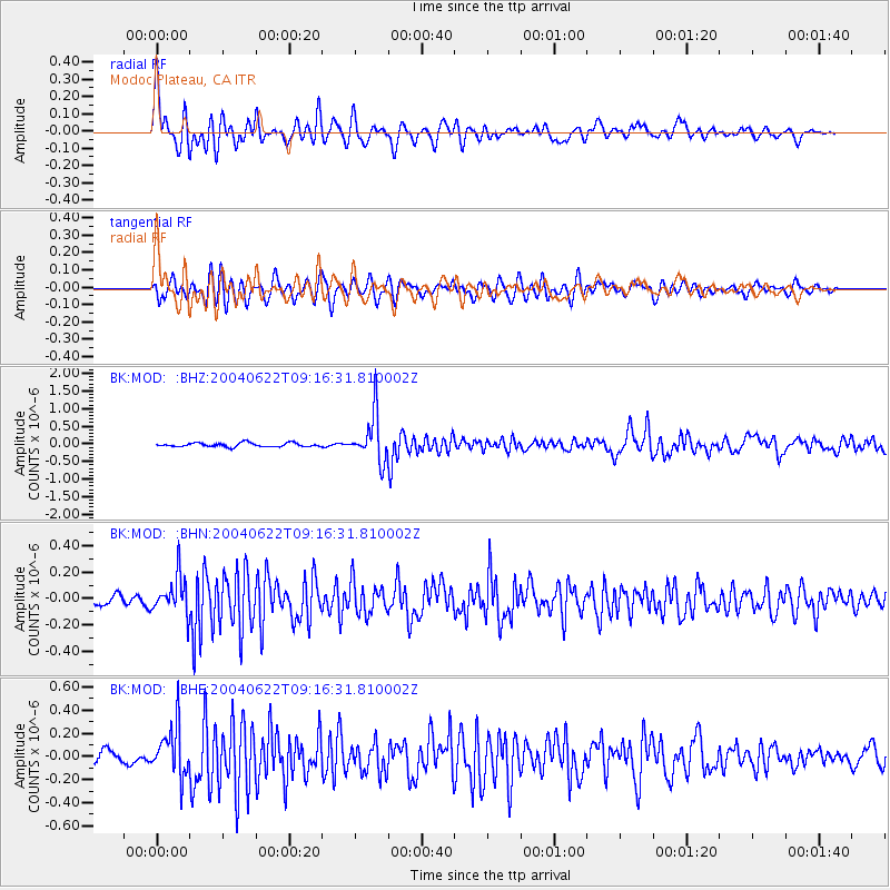
Signal To Noise
| Channel | StoN | STA | LTA |
| BK:MOD: :BHN:20040622T09:16:31.810002Z | 3.4114761 | 1.408947E-7 | 4.1300215E-8 |
| BK:MOD: :BHE:20040622T09:16:31.810002Z | 4.8756423 | 2.1497932E-7 | 4.4092513E-8 |
| BK:MOD: :BHZ:20040622T09:16:31.810002Z | 12.291489 | 6.6831524E-7 | 5.4372197E-8 |
| Arrivals |
| Ps | 4.3 SECOND |
| PpPs | 15 SECOND |
| PsPs/PpSs | 20 SECOND |


