You are here: Home > Network List > BK - Berkeley Digital Seismograph Network Stations List
> Station MOD Modoc Plateau, CA > Earthquake Result Viewer
MOD Modoc Plateau, CA - Earthquake Result Viewer
| Earthquake location: |
Mariana Islands |
| Earthquake latitude/longitude: |
14.5/147.0 |
| Earthquake time(UTC): |
2004/10/04 (278) 19:20:34 GMT |
| Earthquake Depth: |
7.2 km |
| Earthquake Magnitude: |
5.9 MB, 5.9 MS, 6.0 MW, 5.9 MW |
| Earthquake Catalog/Contributor: |
WHDF/NEIC |
|
| Network: |
BK Berkeley Digital Seismograph Network |
| Station: |
MOD Modoc Plateau, CA |
| Lat/Lon: |
41.90 N/120.30 W |
| Elevation: |
1554 m |
|
| Distance: |
82.4 deg |
| Az: |
48.786 deg |
| Baz: |
282.628 deg |
| Ray Param: |
0.046906747 |
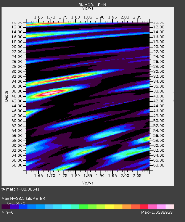
| Estimated Moho Depth: |
38.5 km |
| Estimated Crust Vp/Vs: |
1.70 |
| Assumed Crust Vp: |
6.566 km/s |
| Estimated Crust Vs: |
3.868 km/s |
| Estimated Crust Poisson's Ratio: |
0.23 |
|
| Radial Match: |
80.36641 % |
| Radial Bump: |
400 |
| Transverse Match: |
69.298004 % |
| Transverse Bump: |
400 |
| SOD ConfigId: |
2459 |
| Insert Time: |
2010-03-05 19:41:26.350 +0000 |
| GWidth: |
2.5 |
| Max Bumps: |
400 |
| Tol: |
0.001 |
|
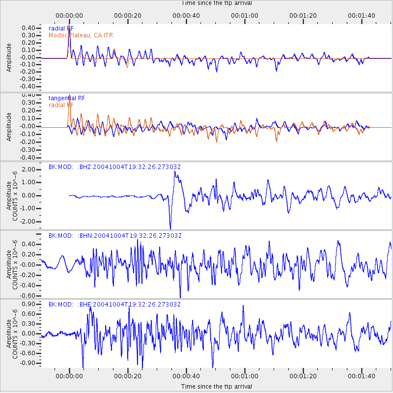
Signal To Noise
| Channel | StoN | STA | LTA |
| BK:MOD: :BHN:20041004T19:32:26.27303Z | 1.3736029 | 1.0453423E-7 | 7.610222E-8 |
| BK:MOD: :BHE:20041004T19:32:26.27303Z | 5.3060765 | 2.5773042E-7 | 4.8572694E-8 |
| BK:MOD: :BHZ:20041004T19:32:26.27303Z | 15.8254175 | 7.308761E-7 | 4.6183683E-8 |
| Arrivals |
| Ps | 4.2 SECOND |
| PpPs | 15 SECOND |
| PsPs/PpSs | 20 SECOND |


