You are here: Home > Network List > TA - USArray Transportable Network (new EarthScope stations) Stations List
> Station R11A Troy Canyon, Currant, NV, USA > Earthquake Result Viewer
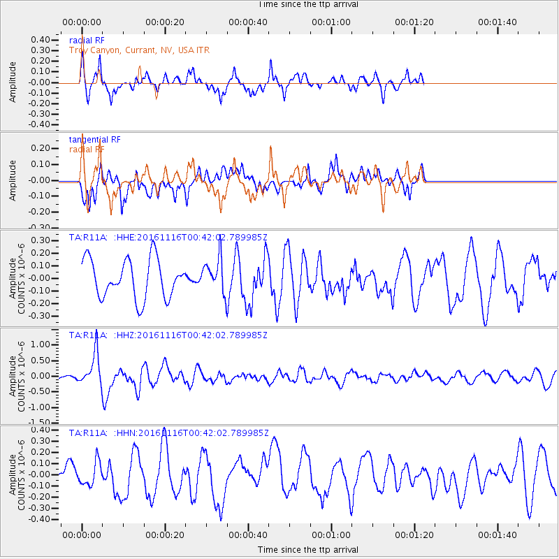
R11A Troy Canyon, Currant, NV, USA - Earthquake Result Viewer
*The percent match for this event was below the threshold and hence no stack was calculated.
| Earthquake location: |
Tonga Islands Region |
| Earthquake latitude/longitude: |
-20.2/-173.0 |
| Earthquake time(UTC): |
2016/11/16 (321) 00:30:28 GMT |
| Earthquake Depth: |
10 km |
| Earthquake Magnitude: |
5.9 MB, 5.6 MWB |
| Earthquake Catalog/Contributor: |
NEIC PDE/NEIC COMCAT |
|
| Network: |
TA USArray Transportable Network (new EarthScope stations) |
| Station: |
R11A Troy Canyon, Currant, NV, USA |
| Lat/Lon: |
38.35 N/115.59 W |
| Elevation: |
1756 m |
|
| Distance: |
79.3 deg |
| Az: |
42.376 deg |
| Baz: |
233.625 deg |
| Ray Param: |
$rayparam |
*The percent match for this event was below the threshold and hence was not used in the summary stack. |
|
| Radial Match: |
68.358665 % |
| Radial Bump: |
362 |
| Transverse Match: |
51.059074 % |
| Transverse Bump: |
371 |
| SOD ConfigId: |
11737051 |
| Insert Time: |
2019-04-26 02:21:11.770 +0000 |
| GWidth: |
2.5 |
| Max Bumps: |
400 |
| Tol: |
0.001 |
|
Signal To Noise
| Channel | StoN | STA | LTA |
| TA:R11A: :HHZ:20161116T00:42:02.789985Z | 3.0200393 | 5.3348657E-7 | 1.7664888E-7 |
| TA:R11A: :HHN:20161116T00:42:02.789985Z | 0.68973005 | 1.09363626E-7 | 1.5856004E-7 |
| TA:R11A: :HHE:20161116T00:42:02.789985Z | 0.8572474 | 1.3229423E-7 | 1.5432445E-7 |
| Arrivals |
| Ps | |
| PpPs | |
| PsPs/PpSs | |


