You are here: Home > Network List > TA - USArray Transportable Network (new EarthScope stations) Stations List
> Station WHTX Lake Whitney, Meridian, TX, USA > Earthquake Result Viewer
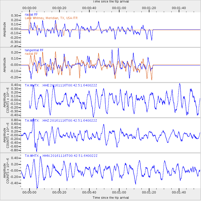
WHTX Lake Whitney, Meridian, TX, USA - Earthquake Result Viewer
*The percent match for this event was below the threshold and hence no stack was calculated.
| Earthquake location: |
Tonga Islands Region |
| Earthquake latitude/longitude: |
-20.2/-173.0 |
| Earthquake time(UTC): |
2016/11/16 (321) 00:30:28 GMT |
| Earthquake Depth: |
10 km |
| Earthquake Magnitude: |
5.9 MB, 5.6 MWB |
| Earthquake Catalog/Contributor: |
NEIC PDE/NEIC COMCAT |
|
| Network: |
TA USArray Transportable Network (new EarthScope stations) |
| Station: |
WHTX Lake Whitney, Meridian, TX, USA |
| Lat/Lon: |
31.99 N/97.46 W |
| Elevation: |
190 m |
|
| Distance: |
88.9 deg |
| Az: |
55.369 deg |
| Baz: |
245.441 deg |
| Ray Param: |
$rayparam |
*The percent match for this event was below the threshold and hence was not used in the summary stack. |
|
| Radial Match: |
54.23045 % |
| Radial Bump: |
400 |
| Transverse Match: |
56.67318 % |
| Transverse Bump: |
366 |
| SOD ConfigId: |
11737051 |
| Insert Time: |
2019-04-26 02:21:19.687 +0000 |
| GWidth: |
2.5 |
| Max Bumps: |
400 |
| Tol: |
0.001 |
|
Signal To Noise
| Channel | StoN | STA | LTA |
| TA:WHTX: :HHZ:20161116T00:42:51.640022Z | 3.658138 | 4.5815753E-7 | 1.2524337E-7 |
| TA:WHTX: :HHN:20161116T00:42:51.640022Z | 1.8019713 | 1.9896139E-7 | 1.1041319E-7 |
| TA:WHTX: :HHE:20161116T00:42:51.640022Z | 0.46288767 | 8.207086E-8 | 1.773019E-7 |
| Arrivals |
| Ps | |
| PpPs | |
| PsPs/PpSs | |


