You are here: Home > Network List > BK - Berkeley Digital Seismograph Network Stations List
> Station MOD Modoc Plateau, CA > Earthquake Result Viewer
MOD Modoc Plateau, CA - Earthquake Result Viewer
| Earthquake location: |
Hokkaido, Japan Region |
| Earthquake latitude/longitude: |
42.9/145.2 |
| Earthquake time(UTC): |
2004/12/06 (341) 14:15:11 GMT |
| Earthquake Depth: |
35 km |
| Earthquake Magnitude: |
6.5 MB, 6.5 MS, 6.8 MW, 6.8 MW |
| Earthquake Catalog/Contributor: |
WHDF/NEIC |
|
| Network: |
BK Berkeley Digital Seismograph Network |
| Station: |
MOD Modoc Plateau, CA |
| Lat/Lon: |
41.90 N/120.30 W |
| Elevation: |
1554 m |
|
| Distance: |
65.9 deg |
| Az: |
54.627 deg |
| Baz: |
306.618 deg |
| Ray Param: |
0.057920393 |
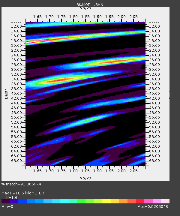
| Estimated Moho Depth: |
18.5 km |
| Estimated Crust Vp/Vs: |
1.60 |
| Assumed Crust Vp: |
6.566 km/s |
| Estimated Crust Vs: |
4.104 km/s |
| Estimated Crust Poisson's Ratio: |
0.18 |
|
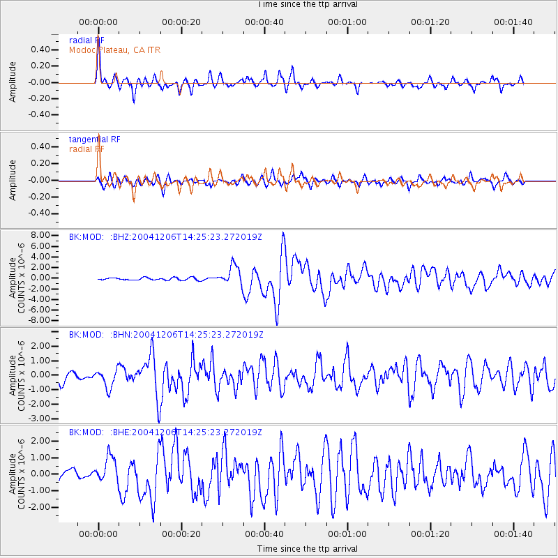
| Radial Match: |
91.865974 % |
| Radial Bump: |
400 |
| Transverse Match: |
78.319695 % |
| Transverse Bump: |
392 |
| SOD ConfigId: |
2459 |
| Insert Time: |
2010-03-05 19:41:31.136 +0000 |
| GWidth: |
2.5 |
| Max Bumps: |
400 |
| Tol: |
0.001 |
|
Signal To Noise
| Channel | StoN | STA | LTA |
| BK:MOD: :BHN:20041206T14:25:23.272019Z | 1.5551647 | 6.5698714E-7 | 4.22455E-7 |
| BK:MOD: :BHE:20041206T14:25:23.272019Z | 2.2906628 | 8.0515343E-7 | 3.5149364E-7 |
| BK:MOD: :BHZ:20041206T14:25:23.272019Z | 8.238904 | 1.909124E-6 | 2.3172062E-7 |
| Arrivals |
| Ps | 1.8 SECOND |
| PpPs | 7.0 SECOND |
| PsPs/PpSs | 8.8 SECOND |


