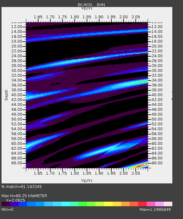
MOD Modoc Plateau, CA - Earthquake Result Viewer
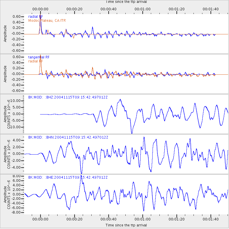
Earthquake location: Near West Coast Of Colombia
Earthquake latitude/longitude: 4.7/-77.5
Earthquake time(UTC): 2004/11/15 (320) 09:06:56 GMT
Earthquake Depth: 15 km
Earthquake Magnitude: 6.6 MB, 7.1 MS, 7.2 MW, 7.1 MW
Earthquake Catalog/Contributor: WHDF/NEIC
Network: BK Berkeley Digital Seismograph Network
Station: MOD Modoc Plateau, CA
Lat/Lon: 41.90 N/120.30 W
Elevation: 1554 m
Distance: 53.1 deg
Az: 320.655 deg
Baz: 122.171 deg
Ray Param: 0.06629703
Estimated Moho Depth: 68.25 km
Estimated Crust Vp/Vs: 2.09
Assumed Crust Vp: 6.566 km/s
Estimated Crust Vs: 3.138 km/s
Estimated Crust Poisson's Ratio: 0.35
Radial Match: 91.163345 %
Radial Bump: 400
Transverse Match: 81.76252 %
Transverse Bump: 400
SOD ConfigId: 2459
Insert Time: 2010-03-05 19:41:35.532 +0000
GWidth: 2.5
Max Bumps: 400
Tol: 0.001

Signal To Noise

ChannelStoNSTALTA
BK:MOD: :BHN:20041115T09:15:42.497012Z6.26582341.0108379E-61.6132563E-7
BK:MOD: :BHE:20041115T09:15:42.497012Z3.2431691.361316E-64.197487E-7
BK:MOD: :BHZ:20041115T09:15:42.497012Z15.682812.811243E-61.7925632E-7
Arrivals
Ps12 SECOND
PpPs31 SECOND
PsPs/PpSs43 SECOND