You are here: Home > Network List > UW - Pacific Northwest Regional Seismic Network Stations List
> Station IZEE Izee, OR, USA > Earthquake Result Viewer
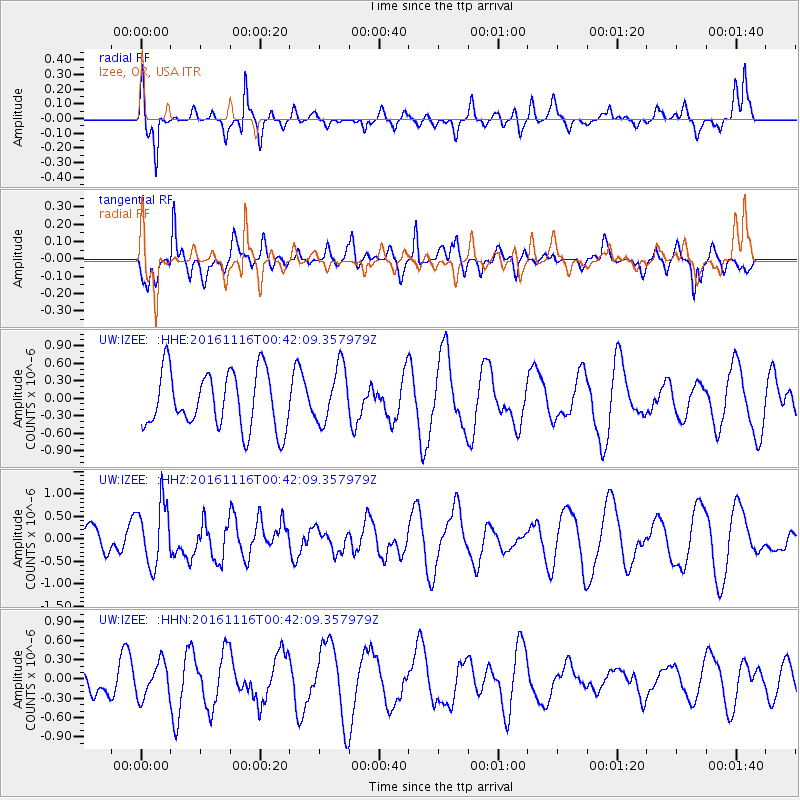
IZEE Izee, OR, USA - Earthquake Result Viewer
*The percent match for this event was below the threshold and hence no stack was calculated.
| Earthquake location: |
Tonga Islands Region |
| Earthquake latitude/longitude: |
-20.2/-173.0 |
| Earthquake time(UTC): |
2016/11/16 (321) 00:30:28 GMT |
| Earthquake Depth: |
10 km |
| Earthquake Magnitude: |
5.9 MB, 5.6 MWB |
| Earthquake Catalog/Contributor: |
NEIC PDE/NEIC COMCAT |
|
| Network: |
UW Pacific Northwest Regional Seismic Network |
| Station: |
IZEE Izee, OR, USA |
| Lat/Lon: |
44.08 N/119.50 W |
| Elevation: |
1293 m |
|
| Distance: |
80.5 deg |
| Az: |
35.949 deg |
| Baz: |
229.919 deg |
| Ray Param: |
$rayparam |
*The percent match for this event was below the threshold and hence was not used in the summary stack. |
|
| Radial Match: |
60.159958 % |
| Radial Bump: |
351 |
| Transverse Match: |
54.147957 % |
| Transverse Bump: |
354 |
| SOD ConfigId: |
11737051 |
| Insert Time: |
2019-04-26 02:21:56.381 +0000 |
| GWidth: |
2.5 |
| Max Bumps: |
400 |
| Tol: |
0.001 |
|
Signal To Noise
| Channel | StoN | STA | LTA |
| UW:IZEE: :HHZ:20161116T00:42:09.357979Z | 1.9824207 | 6.934248E-7 | 3.4978692E-7 |
| UW:IZEE: :HHN:20161116T00:42:09.357979Z | 0.46788272 | 2.7210424E-7 | 5.815651E-7 |
| UW:IZEE: :HHE:20161116T00:42:09.357979Z | 0.9857612 | 4.803272E-7 | 4.8726525E-7 |
| Arrivals |
| Ps | |
| PpPs | |
| PsPs/PpSs | |


