You are here: Home > Network List > UW - Pacific Northwest Regional Seismic Network Stations List
> Station UMAT Pilot Rock, OR, USA > Earthquake Result Viewer
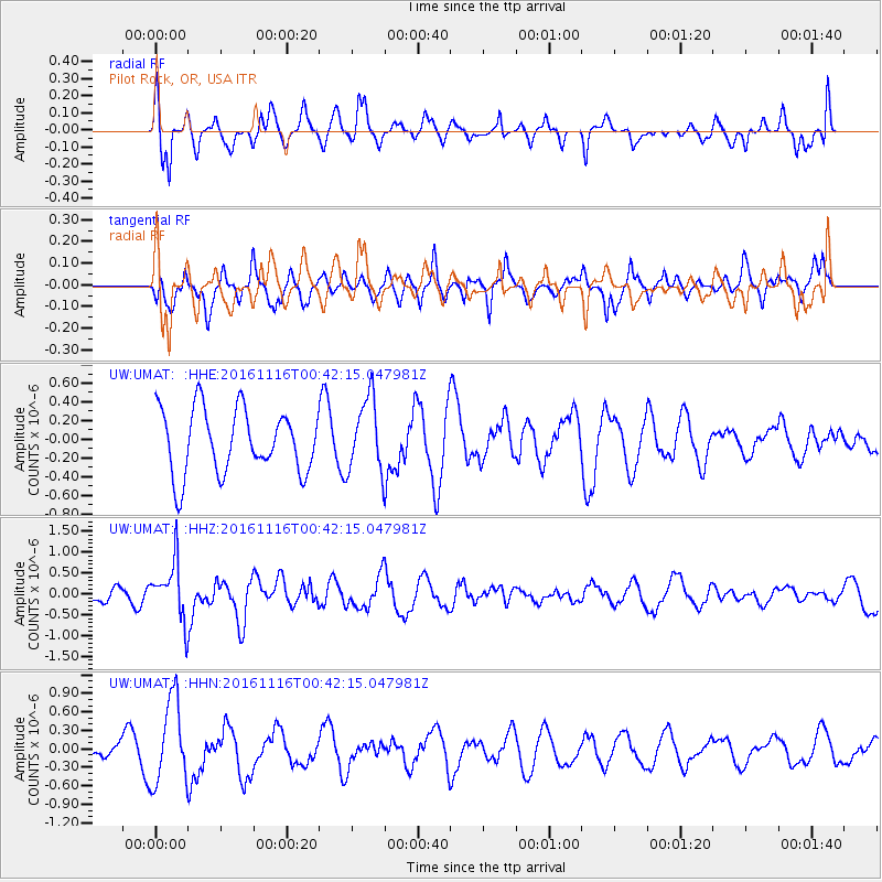
UMAT Pilot Rock, OR, USA - Earthquake Result Viewer
*The percent match for this event was below the threshold and hence no stack was calculated.
| Earthquake location: |
Tonga Islands Region |
| Earthquake latitude/longitude: |
-20.2/-173.0 |
| Earthquake time(UTC): |
2016/11/16 (321) 00:30:28 GMT |
| Earthquake Depth: |
10 km |
| Earthquake Magnitude: |
5.9 MB, 5.6 MWB |
| Earthquake Catalog/Contributor: |
NEIC PDE/NEIC COMCAT |
|
| Network: |
UW Pacific Northwest Regional Seismic Network |
| Station: |
UMAT Pilot Rock, OR, USA |
| Lat/Lon: |
45.29 N/118.96 W |
| Elevation: |
1318 m |
|
| Distance: |
81.6 deg |
| Az: |
35.264 deg |
| Baz: |
230.194 deg |
| Ray Param: |
$rayparam |
*The percent match for this event was below the threshold and hence was not used in the summary stack. |
|
| Radial Match: |
50.214622 % |
| Radial Bump: |
393 |
| Transverse Match: |
43.160816 % |
| Transverse Bump: |
371 |
| SOD ConfigId: |
11737051 |
| Insert Time: |
2019-04-26 02:22:02.054 +0000 |
| GWidth: |
2.5 |
| Max Bumps: |
400 |
| Tol: |
0.001 |
|
Signal To Noise
| Channel | StoN | STA | LTA |
| UW:UMAT: :HHZ:20161116T00:42:15.047981Z | 2.1692374 | 6.8723983E-7 | 3.168117E-7 |
| UW:UMAT: :HHN:20161116T00:42:15.047981Z | 1.5304935 | 6.8222647E-7 | 4.457559E-7 |
| UW:UMAT: :HHE:20161116T00:42:15.047981Z | 1.1401552 | 3.8897275E-7 | 3.4115772E-7 |
| Arrivals |
| Ps | |
| PpPs | |
| PsPs/PpSs | |


