You are here: Home > Network List > BK - Berkeley Digital Seismograph Network Stations List
> Station MOD Modoc Plateau, CA > Earthquake Result Viewer
MOD Modoc Plateau, CA - Earthquake Result Viewer
| Earthquake location: |
Solomon Islands |
| Earthquake latitude/longitude: |
-11.0/162.2 |
| Earthquake time(UTC): |
2004/10/08 (282) 08:27:53 GMT |
| Earthquake Depth: |
36 km |
| Earthquake Magnitude: |
6.1 MB, 6.9 MS, 6.8 MW, 6.8 MW |
| Earthquake Catalog/Contributor: |
WHDF/NEIC |
|
| Network: |
BK Berkeley Digital Seismograph Network |
| Station: |
MOD Modoc Plateau, CA |
| Lat/Lon: |
41.90 N/120.30 W |
| Elevation: |
1554 m |
|
| Distance: |
88.1 deg |
| Az: |
46.828 deg |
| Baz: |
253.616 deg |
| Ray Param: |
0.042766694 |
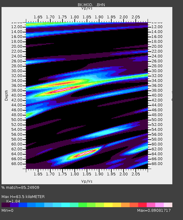
| Estimated Moho Depth: |
63.5 km |
| Estimated Crust Vp/Vs: |
1.84 |
| Assumed Crust Vp: |
6.566 km/s |
| Estimated Crust Vs: |
3.569 km/s |
| Estimated Crust Poisson's Ratio: |
0.29 |
|
| Radial Match: |
85.24909 % |
| Radial Bump: |
400 |
| Transverse Match: |
68.92442 % |
| Transverse Bump: |
400 |
| SOD ConfigId: |
2459 |
| Insert Time: |
2010-03-05 19:41:41.402 +0000 |
| GWidth: |
2.5 |
| Max Bumps: |
400 |
| Tol: |
0.001 |
|
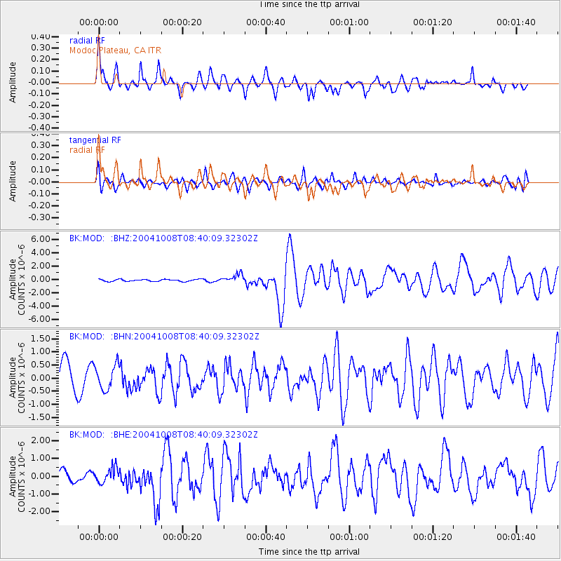
Signal To Noise
| Channel | StoN | STA | LTA |
| BK:MOD: :BHN:20041008T08:40:09.32302Z | 0.94269365 | 4.6351187E-7 | 4.9168875E-7 |
| BK:MOD: :BHE:20041008T08:40:09.32302Z | 1.1688814 | 4.3798613E-7 | 3.747054E-7 |
| BK:MOD: :BHZ:20041008T08:40:09.32302Z | 4.47939 | 6.751996E-7 | 1.507347E-7 |
| Arrivals |
| Ps | 8.3 SECOND |
| PpPs | 27 SECOND |
| PsPs/PpSs | 35 SECOND |


