You are here: Home > Network List > BK - Berkeley Digital Seismograph Network Stations List
> Station ORV Oroville Dam, CA > Earthquake Result Viewer
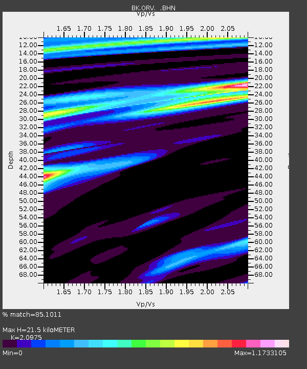
ORV Oroville Dam, CA - Earthquake Result Viewer
| Earthquake location: |
South Of Panama |
| Earthquake latitude/longitude: |
5.1/-82.4 |
| Earthquake time(UTC): |
2005/05/05 (125) 23:41:53 GMT |
| Earthquake Depth: |
10 km |
| Earthquake Magnitude: |
5.7 MB, 5.0 MS, 5.9 MW, 5.8 MW |
| Earthquake Catalog/Contributor: |
WHDF/NEIC |
|
| Network: |
BK Berkeley Digital Seismograph Network |
| Station: |
ORV Oroville Dam, CA |
| Lat/Lon: |
39.55 N/121.50 W |
| Elevation: |
335 m |
|
| Distance: |
49.2 deg |
| Az: |
319.903 deg |
| Baz: |
123.914 deg |
| Ray Param: |
0.068856776 |
| Estimated Moho Depth: |
21.5 km |
| Estimated Crust Vp/Vs: |
2.10 |
| Assumed Crust Vp: |
6.597 km/s |
| Estimated Crust Vs: |
3.145 km/s |
| Estimated Crust Poisson's Ratio: |
0.35 |
|
| Radial Match: |
85.1011 % |
| Radial Bump: |
352 |
| Transverse Match: |
61.750282 % |
| Transverse Bump: |
400 |
| SOD ConfigId: |
124340 |
| Insert Time: |
2010-03-05 19:42:16.558 +0000 |
| GWidth: |
2.5 |
| Max Bumps: |
400 |
| Tol: |
0.001 |
|

Signal To Noise
| Channel | StoN | STA | LTA |
| BK:ORV: :BHN:20050505T23:50:10.422014Z | 2.0767965 | 8.0957314E-8 | 3.8981824E-8 |
| BK:ORV: :BHE:20050505T23:50:10.422014Z | 1.6000404 | 9.2936105E-8 | 5.8083597E-8 |
| BK:ORV: :BHZ:20050505T23:50:10.422014Z | 3.7948616 | 2.0769959E-7 | 5.4731796E-8 |
| Arrivals |
| Ps | 3.8 SECOND |
| PpPs | 9.6 SECOND |
| PsPs/PpSs | 13 SECOND |


