You are here: Home > Network List > AK - Alaska Regional Network Stations List
> Station CUT Chulitna, AK, USA > Earthquake Result Viewer
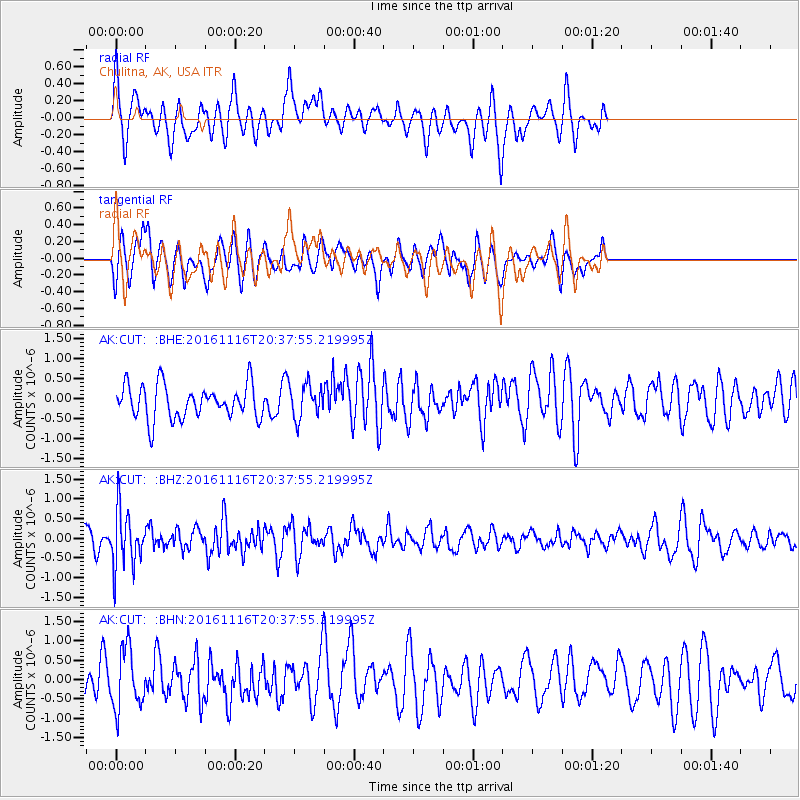
CUT Chulitna, AK, USA - Earthquake Result Viewer
*The percent match for this event was below the threshold and hence no stack was calculated.
| Earthquake location: |
South Of Fiji Islands |
| Earthquake latitude/longitude: |
-22.1/-177.6 |
| Earthquake time(UTC): |
2016/11/16 (321) 20:26:15 GMT |
| Earthquake Depth: |
305 km |
| Earthquake Magnitude: |
5.5 MB |
| Earthquake Catalog/Contributor: |
NEIC PDE/NEIC COMCAT |
|
| Network: |
AK Alaska Regional Network |
| Station: |
CUT Chulitna, AK, USA |
| Lat/Lon: |
62.41 N/150.26 W |
| Elevation: |
574 m |
|
| Distance: |
87.0 deg |
| Az: |
12.373 deg |
| Baz: |
205.257 deg |
| Ray Param: |
$rayparam |
*The percent match for this event was below the threshold and hence was not used in the summary stack. |
|
| Radial Match: |
61.904835 % |
| Radial Bump: |
400 |
| Transverse Match: |
64.37912 % |
| Transverse Bump: |
400 |
| SOD ConfigId: |
11737051 |
| Insert Time: |
2019-04-26 02:28:23.667 +0000 |
| GWidth: |
2.5 |
| Max Bumps: |
400 |
| Tol: |
0.001 |
|
Signal To Noise
| Channel | StoN | STA | LTA |
| AK:CUT: :BHZ:20161116T20:37:55.219995Z | 2.7747862 | 7.220902E-7 | 2.6023272E-7 |
| AK:CUT: :BHN:20161116T20:37:55.219995Z | 1.4364369 | 7.7496094E-7 | 5.3950225E-7 |
| AK:CUT: :BHE:20161116T20:37:55.219995Z | 0.9857535 | 4.1091127E-7 | 4.1684993E-7 |
| Arrivals |
| Ps | |
| PpPs | |
| PsPs/PpSs | |


