You are here: Home > Network List > BK - Berkeley Digital Seismograph Network Stations List
> Station ORV Oroville Dam, CA > Earthquake Result Viewer
ORV Oroville Dam, CA - Earthquake Result Viewer

| Earthquake location: |
Southeast Of Loyalty Islands |
| Earthquake latitude/longitude: |
-22.0/170.6 |
| Earthquake time(UTC): |
2005/04/11 (101) 17:08:53 GMT |
| Earthquake Depth: |
68 km |
| Earthquake Magnitude: |
6.0 MB, 6.8 MW, 6.8 MW |
| Earthquake Catalog/Contributor: |
WHDF/NEIC |
|
| Network: |
BK Berkeley Digital Seismograph Network |
| Station: |
ORV Oroville Dam, CA |
| Lat/Lon: |
39.55 N/121.50 W |
| Elevation: |
335 m |
|
| Distance: |
88.0 deg |
| Az: |
45.78 deg |
| Baz: |
239.366 deg |
| Ray Param: |
0.04275169 |
| Estimated Moho Depth: |
33.75 km |
| Estimated Crust Vp/Vs: |
1.87 |
| Assumed Crust Vp: |
6.597 km/s |
| Estimated Crust Vs: |
3.533 km/s |
| Estimated Crust Poisson's Ratio: |
0.30 |
|
| Radial Match: |
93.95358 % |
| Radial Bump: |
400 |
| Transverse Match: |
88.18438 % |
| Transverse Bump: |
400 |
| SOD ConfigId: |
2459 |
| Insert Time: |
2010-03-05 19:42:54.051 +0000 |
| GWidth: |
2.5 |
| Max Bumps: |
400 |
| Tol: |
0.001 |
|
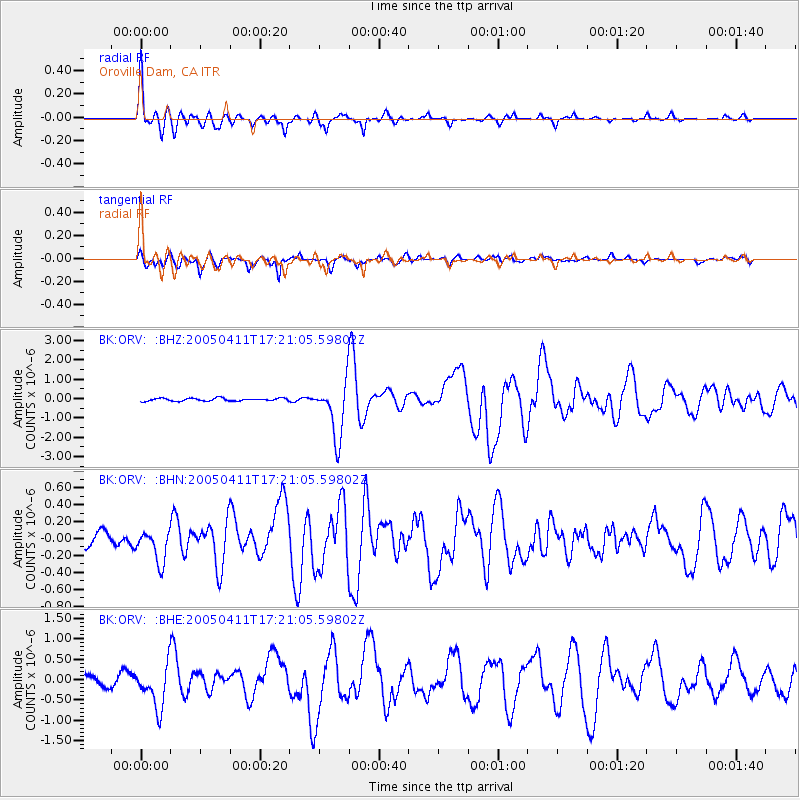
Signal To Noise
| Channel | StoN | STA | LTA |
| BK:ORV: :BHN:20050411T17:21:05.59802Z | 2.9717252 | 1.8741362E-7 | 6.30656E-8 |
| BK:ORV: :BHE:20050411T17:21:05.59802Z | 4.794666 | 5.272949E-7 | 1.0997532E-7 |
| BK:ORV: :BHZ:20050411T17:21:05.59802Z | 19.416368 | 1.4253693E-6 | 7.341071E-8 |
| Arrivals |
| Ps | 4.5 SECOND |
| PpPs | 14 SECOND |
| PsPs/PpSs | 19 SECOND |


