You are here: Home > Network List > TA - USArray Transportable Network (new EarthScope stations) Stations List
> Station ABTX Abilene, Hawley, TX, USA > Earthquake Result Viewer
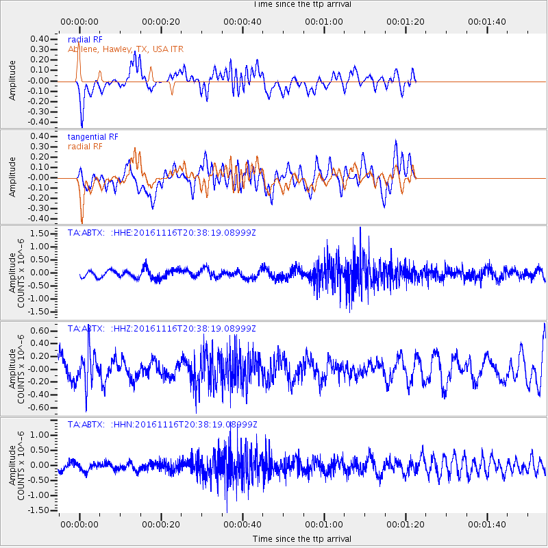
ABTX Abilene, Hawley, TX, USA - Earthquake Result Viewer
*The percent match for this event was below the threshold and hence no stack was calculated.
| Earthquake location: |
South Of Fiji Islands |
| Earthquake latitude/longitude: |
-22.1/-177.6 |
| Earthquake time(UTC): |
2016/11/16 (321) 20:26:15 GMT |
| Earthquake Depth: |
305 km |
| Earthquake Magnitude: |
5.5 MB |
| Earthquake Catalog/Contributor: |
NEIC PDE/NEIC COMCAT |
|
| Network: |
TA USArray Transportable Network (new EarthScope stations) |
| Station: |
ABTX Abilene, Hawley, TX, USA |
| Lat/Lon: |
32.62 N/99.64 W |
| Elevation: |
502 m |
|
| Distance: |
92.2 deg |
| Az: |
55.685 deg |
| Baz: |
245.166 deg |
| Ray Param: |
$rayparam |
*The percent match for this event was below the threshold and hence was not used in the summary stack. |
|
| Radial Match: |
59.994102 % |
| Radial Bump: |
400 |
| Transverse Match: |
47.90867 % |
| Transverse Bump: |
400 |
| SOD ConfigId: |
11737051 |
| Insert Time: |
2019-04-26 02:32:33.752 +0000 |
| GWidth: |
2.5 |
| Max Bumps: |
400 |
| Tol: |
0.001 |
|
Signal To Noise
| Channel | StoN | STA | LTA |
| TA:ABTX: :HHZ:20161116T20:38:19.08999Z | 2.0017686 | 2.6343258E-7 | 1.3159992E-7 |
| TA:ABTX: :HHN:20161116T20:38:19.08999Z | 1.2715237 | 1.3302122E-7 | 1.046156E-7 |
| TA:ABTX: :HHE:20161116T20:38:19.08999Z | 1.0654559 | 1.6771793E-7 | 1.5741423E-7 |
| Arrivals |
| Ps | |
| PpPs | |
| PsPs/PpSs | |


