You are here: Home > Network List > TA - USArray Transportable Network (new EarthScope stations) Stations List
> Station J26L Joseph Creek, AK, USA > Earthquake Result Viewer
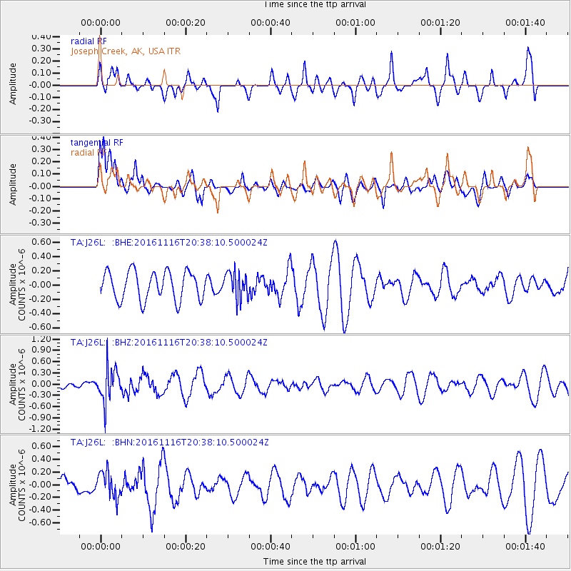
J26L Joseph Creek, AK, USA - Earthquake Result Viewer
*The percent match for this event was below the threshold and hence no stack was calculated.
| Earthquake location: |
South Of Fiji Islands |
| Earthquake latitude/longitude: |
-22.1/-177.6 |
| Earthquake time(UTC): |
2016/11/16 (321) 20:26:15 GMT |
| Earthquake Depth: |
305 km |
| Earthquake Magnitude: |
5.5 MB |
| Earthquake Catalog/Contributor: |
NEIC PDE/NEIC COMCAT |
|
| Network: |
TA USArray Transportable Network (new EarthScope stations) |
| Station: |
J26L Joseph Creek, AK, USA |
| Lat/Lon: |
64.50 N/143.56 W |
| Elevation: |
1144 m |
|
| Distance: |
90.3 deg |
| Az: |
14.029 deg |
| Baz: |
211.283 deg |
| Ray Param: |
$rayparam |
*The percent match for this event was below the threshold and hence was not used in the summary stack. |
|
| Radial Match: |
47.94188 % |
| Radial Bump: |
400 |
| Transverse Match: |
60.593025 % |
| Transverse Bump: |
400 |
| SOD ConfigId: |
11737051 |
| Insert Time: |
2019-04-26 02:32:41.672 +0000 |
| GWidth: |
2.5 |
| Max Bumps: |
400 |
| Tol: |
0.001 |
|
Signal To Noise
| Channel | StoN | STA | LTA |
| TA:J26L: :BHZ:20161116T20:38:10.500024Z | 3.2582996 | 4.561686E-7 | 1.4000204E-7 |
| TA:J26L: :BHN:20161116T20:38:10.500024Z | 1.2849196 | 2.0836214E-7 | 1.6215967E-7 |
| TA:J26L: :BHE:20161116T20:38:10.500024Z | 0.93582773 | 1.8686008E-7 | 1.996736E-7 |
| Arrivals |
| Ps | |
| PpPs | |
| PsPs/PpSs | |


