You are here: Home > Network List > BK - Berkeley Digital Seismograph Network Stations List
> Station ORV Oroville Dam, CA > Earthquake Result Viewer
ORV Oroville Dam, CA - Earthquake Result Viewer
| Earthquake location: |
Vanuatu Islands Region |
| Earthquake latitude/longitude: |
-21.1/173.9 |
| Earthquake time(UTC): |
2005/08/09 (221) 14:12:21 GMT |
| Earthquake Depth: |
35 km |
| Earthquake Magnitude: |
5.3 MB, 5.9 MS, 6.1 MW, 6.0 MW |
| Earthquake Catalog/Contributor: |
WHDF/NEIC |
|
| Network: |
BK Berkeley Digital Seismograph Network |
| Station: |
ORV Oroville Dam, CA |
| Lat/Lon: |
39.55 N/121.50 W |
| Elevation: |
335 m |
|
| Distance: |
85.3 deg |
| Az: |
44.5 deg |
| Baz: |
237.841 deg |
| Ray Param: |
0.044834897 |
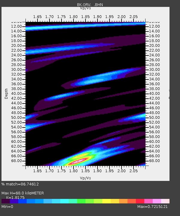
| Estimated Moho Depth: |
68.0 km |
| Estimated Crust Vp/Vs: |
1.82 |
| Assumed Crust Vp: |
6.597 km/s |
| Estimated Crust Vs: |
3.63 km/s |
| Estimated Crust Poisson's Ratio: |
0.28 |
|
| Radial Match: |
86.74612 % |
| Radial Bump: |
400 |
| Transverse Match: |
78.41182 % |
| Transverse Bump: |
400 |
| SOD ConfigId: |
2475 |
| Insert Time: |
2010-03-05 19:43:06.840 +0000 |
| GWidth: |
2.5 |
| Max Bumps: |
400 |
| Tol: |
0.001 |
|
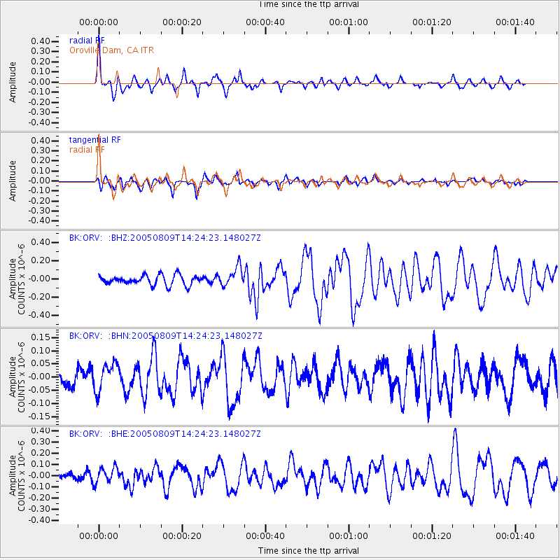
Signal To Noise
| Channel | StoN | STA | LTA |
| BK:ORV: :BHN:20050809T14:24:23.148027Z | 1.953702 | 5.4944543E-8 | 2.81233E-8 |
| BK:ORV: :BHE:20050809T14:24:23.148027Z | 1.5512086 | 6.798071E-8 | 4.3824347E-8 |
| BK:ORV: :BHZ:20050809T14:24:23.148027Z | 2.042799 | 1.0942197E-7 | 5.356473E-8 |
| Arrivals |
| Ps | 8.6 SECOND |
| PpPs | 28 SECOND |
| PsPs/PpSs | 37 SECOND |


