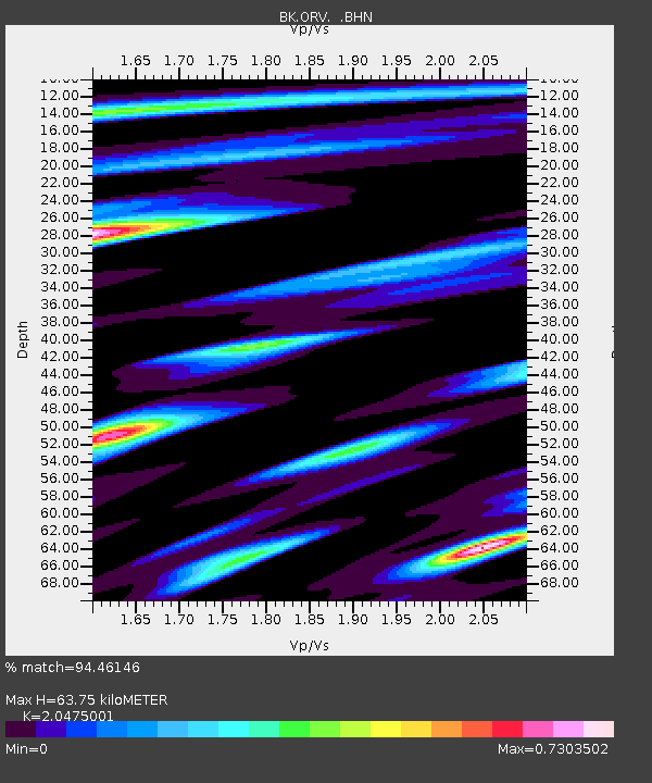
ORV Oroville Dam, CA - Earthquake Result Viewer

Earthquake location: Near East Coast Of Honshu, Japan
Earthquake latitude/longitude: 38.3/142.0
Earthquake time(UTC): 2005/08/16 (228) 02:46:28 GMT
Earthquake Depth: 36 km
Earthquake Magnitude: 6.5 MB, 6.8 MS, 7.2 MW, 7.1 MW
Earthquake Catalog/Contributor: WHDF/NEIC
Network: BK Berkeley Digital Seismograph Network
Station: ORV Oroville Dam, CA
Lat/Lon: 39.55 N/121.50 W
Elevation: 335 m
Distance: 71.2 deg
Az: 54.258 deg
Baz: 304.281 deg
Ray Param: 0.054449376
Estimated Moho Depth: 63.75 km
Estimated Crust Vp/Vs: 2.05
Assumed Crust Vp: 6.597 km/s
Estimated Crust Vs: 3.222 km/s
Estimated Crust Poisson's Ratio: 0.34
Radial Match: 94.46146 %
Radial Bump: 365
Transverse Match: 85.58211 %
Transverse Bump: 400
SOD ConfigId: 2475
Insert Time: 2010-03-05 19:43:11.318 +0000
GWidth: 2.5
Max Bumps: 400
Tol: 0.001

Signal To Noise

ChannelStoNSTALTA
BK:ORV: :BHN:20050816T02:57:12.54801Z4.13433932.1750523E-75.260943E-8
BK:ORV: :BHE:20050816T02:57:12.54801Z5.05614662.892102E-75.7199724E-8
BK:ORV: :BHZ:20050816T02:57:12.54801Z10.5611317.1091824E-76.73146E-8
Arrivals
Ps10 SECOND
PpPs28 SECOND
PsPs/PpSs39 SECOND