You are here: Home > Network List > BK - Berkeley Digital Seismograph Network Stations List
> Station ORV Oroville Dam, CA > Earthquake Result Viewer
ORV Oroville Dam, CA - Earthquake Result Viewer
| Earthquake location: |
Near Coast Of Northern Chile |
| Earthquake latitude/longitude: |
-22.9/-70.4 |
| Earthquake time(UTC): |
2007/11/15 (319) 15:03:08 GMT |
| Earthquake Depth: |
27 km |
| Earthquake Magnitude: |
5.8 MB, 6.1 MW, 5.5 ML |
| Earthquake Catalog/Contributor: |
WHDF/NEIC |
|
| Network: |
BK Berkeley Digital Seismograph Network |
| Station: |
ORV Oroville Dam, CA |
| Lat/Lon: |
39.55 N/121.50 W |
| Elevation: |
335 m |
|
| Distance: |
78.3 deg |
| Az: |
322.093 deg |
| Baz: |
132.864 deg |
| Ray Param: |
0.049701884 |
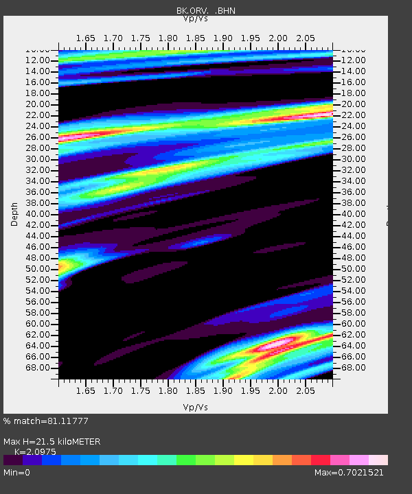
| Estimated Moho Depth: |
21.5 km |
| Estimated Crust Vp/Vs: |
2.10 |
| Assumed Crust Vp: |
6.597 km/s |
| Estimated Crust Vs: |
3.145 km/s |
| Estimated Crust Poisson's Ratio: |
0.35 |
|
| Radial Match: |
81.11777 % |
| Radial Bump: |
400 |
| Transverse Match: |
79.33632 % |
| Transverse Bump: |
400 |
| SOD ConfigId: |
2564 |
| Insert Time: |
2010-03-05 19:43:32.282 +0000 |
| GWidth: |
2.5 |
| Max Bumps: |
400 |
| Tol: |
0.001 |
|

Signal To Noise
| Channel | StoN | STA | LTA |
| BK:ORV: :BHN:20071115T15:14:35.085022Z | 0.87984204 | 1.5118859E-7 | 1.7183605E-7 |
| BK:ORV: :BHE:20071115T15:14:35.085022Z | 1.0021383 | 1.8559469E-7 | 1.8519867E-7 |
| BK:ORV: :BHZ:20071115T15:14:35.085022Z | 2.263044 | 4.7656238E-7 | 2.1058466E-7 |
| Arrivals |
| Ps | 3.7 SECOND |
| PpPs | 9.8 SECOND |
| PsPs/PpSs | 14 SECOND |


