You are here: Home > Network List > TA - USArray Transportable Network (new EarthScope stations) Stations List
> Station D25K Kavik River, AK, USA > Earthquake Result Viewer
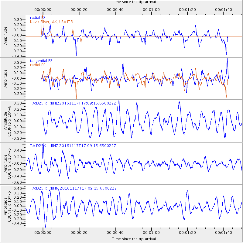
D25K Kavik River, AK, USA - Earthquake Result Viewer
*The percent match for this event was below the threshold and hence no stack was calculated.
| Earthquake location: |
Banda Sea |
| Earthquake latitude/longitude: |
-6.3/130.5 |
| Earthquake time(UTC): |
2016/11/17 (322) 16:56:43 GMT |
| Earthquake Depth: |
107 km |
| Earthquake Magnitude: |
5.5 MWW, 5.5 MWB |
| Earthquake Catalog/Contributor: |
NEIC PDE/NEIC COMCAT |
|
| Network: |
TA USArray Transportable Network (new EarthScope stations) |
| Station: |
D25K Kavik River, AK, USA |
| Lat/Lon: |
69.32 N/146.38 W |
| Elevation: |
770 m |
|
| Distance: |
93.4 deg |
| Az: |
20.686 deg |
| Baz: |
261.322 deg |
| Ray Param: |
$rayparam |
*The percent match for this event was below the threshold and hence was not used in the summary stack. |
|
| Radial Match: |
56.778236 % |
| Radial Bump: |
400 |
| Transverse Match: |
44.035023 % |
| Transverse Bump: |
400 |
| SOD ConfigId: |
11737051 |
| Insert Time: |
2019-04-26 02:38:07.299 +0000 |
| GWidth: |
2.5 |
| Max Bumps: |
400 |
| Tol: |
0.001 |
|
Signal To Noise
| Channel | StoN | STA | LTA |
| TA:D25K: :BHZ:20161117T17:09:15.650022Z | 1.5427226 | 2.3155579E-7 | 1.5009554E-7 |
| TA:D25K: :BHN:20161117T17:09:15.650022Z | 2.4246342 | 2.8356948E-7 | 1.16953515E-7 |
| TA:D25K: :BHE:20161117T17:09:15.650022Z | 1.5033305 | 1.732327E-7 | 1.15232616E-7 |
| Arrivals |
| Ps | |
| PpPs | |
| PsPs/PpSs | |


