You are here: Home > Network List > TA - USArray Transportable Network (new EarthScope stations) Stations List
> Station I23K Minto, Yukon-Koyukuk, AK, USA > Earthquake Result Viewer
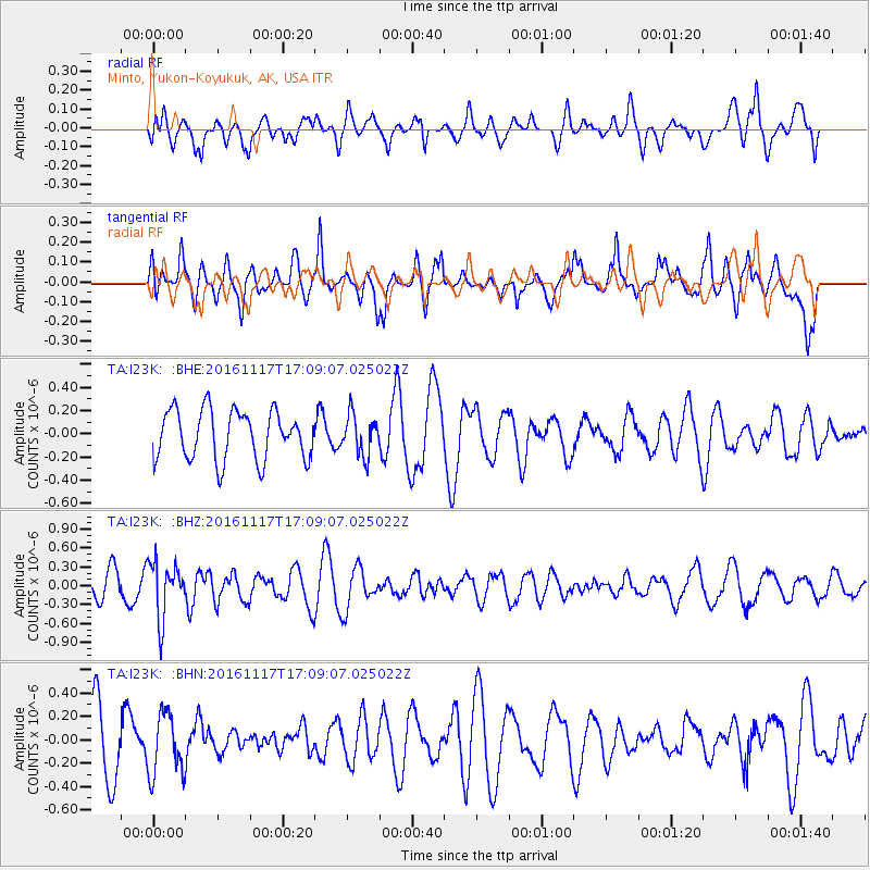
I23K Minto, Yukon-Koyukuk, AK, USA - Earthquake Result Viewer
*The percent match for this event was below the threshold and hence no stack was calculated.
| Earthquake location: |
Banda Sea |
| Earthquake latitude/longitude: |
-6.3/130.5 |
| Earthquake time(UTC): |
2016/11/17 (322) 16:56:43 GMT |
| Earthquake Depth: |
107 km |
| Earthquake Magnitude: |
5.5 MWW, 5.5 MWB |
| Earthquake Catalog/Contributor: |
NEIC PDE/NEIC COMCAT |
|
| Network: |
TA USArray Transportable Network (new EarthScope stations) |
| Station: |
I23K Minto, Yukon-Koyukuk, AK, USA |
| Lat/Lon: |
65.15 N/149.36 W |
| Elevation: |
149 m |
|
| Distance: |
91.5 deg |
| Az: |
24.612 deg |
| Baz: |
258.4 deg |
| Ray Param: |
$rayparam |
*The percent match for this event was below the threshold and hence was not used in the summary stack. |
|
| Radial Match: |
36.191776 % |
| Radial Bump: |
400 |
| Transverse Match: |
58.94568 % |
| Transverse Bump: |
400 |
| SOD ConfigId: |
11737051 |
| Insert Time: |
2019-04-26 02:38:14.013 +0000 |
| GWidth: |
2.5 |
| Max Bumps: |
400 |
| Tol: |
0.001 |
|
Signal To Noise
| Channel | StoN | STA | LTA |
| TA:I23K: :BHZ:20161117T17:09:07.025022Z | 2.5435007 | 4.4550717E-7 | 1.7515514E-7 |
| TA:I23K: :BHN:20161117T17:09:07.025022Z | 1.2192906 | 2.6612003E-7 | 2.1825808E-7 |
| TA:I23K: :BHE:20161117T17:09:07.025022Z | 0.8228953 | 1.7410721E-7 | 2.1157881E-7 |
| Arrivals |
| Ps | |
| PpPs | |
| PsPs/PpSs | |


