You are here: Home > Network List > BK - Berkeley Digital Seismograph Network Stations List
> Station ORV Oroville Dam, CA > Earthquake Result Viewer
ORV Oroville Dam, CA - Earthquake Result Viewer
| Earthquake location: |
Near Coast Of Peru |
| Earthquake latitude/longitude: |
-13.6/-76.6 |
| Earthquake time(UTC): |
2007/08/17 (229) 13:18:13 GMT |
| Earthquake Depth: |
48 km |
| Earthquake Magnitude: |
5.6 MB, 5.6 MS, 5.9 MW |
| Earthquake Catalog/Contributor: |
WHDF/NEIC |
|
| Network: |
BK Berkeley Digital Seismograph Network |
| Station: |
ORV Oroville Dam, CA |
| Lat/Lon: |
39.55 N/121.50 W |
| Elevation: |
335 m |
|
| Distance: |
67.4 deg |
| Az: |
323.766 deg |
| Baz: |
131.98 deg |
| Ray Param: |
0.056880187 |
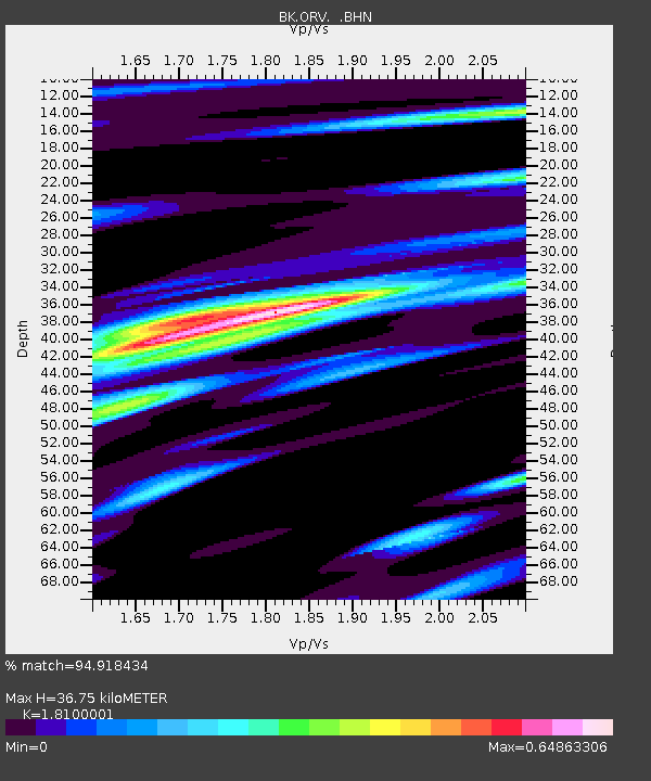
| Estimated Moho Depth: |
36.75 km |
| Estimated Crust Vp/Vs: |
1.81 |
| Assumed Crust Vp: |
6.597 km/s |
| Estimated Crust Vs: |
3.645 km/s |
| Estimated Crust Poisson's Ratio: |
0.28 |
|
| Radial Match: |
94.918434 % |
| Radial Bump: |
318 |
| Transverse Match: |
88.3388 % |
| Transverse Bump: |
375 |
| SOD ConfigId: |
2564 |
| Insert Time: |
2010-03-05 19:44:01.210 +0000 |
| GWidth: |
2.5 |
| Max Bumps: |
400 |
| Tol: |
0.001 |
|

Signal To Noise
| Channel | StoN | STA | LTA |
| BK:ORV: :BHN:20070817T13:28:32.785002Z | 8.5776415 | 2.5585416E-7 | 2.9828033E-8 |
| BK:ORV: :BHE:20070817T13:28:32.785002Z | 6.173743 | 2.9807418E-7 | 4.8280953E-8 |
| BK:ORV: :BHZ:20070817T13:28:32.785002Z | 23.580229 | 8.8228876E-7 | 3.7416463E-8 |
| Arrivals |
| Ps | 4.7 SECOND |
| PpPs | 15 SECOND |
| PsPs/PpSs | 20 SECOND |


