You are here: Home > Network List > US - United States National Seismic Network Stations List
> Station MSO Missoula, Montana, USA > Earthquake Result Viewer
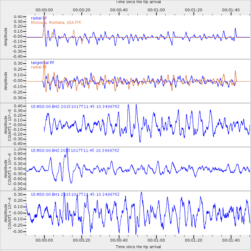
MSO Missoula, Montana, USA - Earthquake Result Viewer
*The percent match for this event was below the threshold and hence no stack was calculated.
| Earthquake location: |
Salta Province, Argentina |
| Earthquake latitude/longitude: |
-25.4/-64.4 |
| Earthquake time(UTC): |
2015/10/17 (290) 11:33:07 GMT |
| Earthquake Depth: |
8.2 km |
| Earthquake Magnitude: |
6.0 MB, 5.9 MWB |
| Earthquake Catalog/Contributor: |
NEIC PDE/NEIC COMCAT |
|
| Network: |
US United States National Seismic Network |
| Station: |
MSO Missoula, Montana, USA |
| Lat/Lon: |
46.83 N/113.94 W |
| Elevation: |
1264 m |
|
| Distance: |
84.7 deg |
| Az: |
328.371 deg |
| Baz: |
136.312 deg |
| Ray Param: |
$rayparam |
*The percent match for this event was below the threshold and hence was not used in the summary stack. |
|
| Radial Match: |
74.68326 % |
| Radial Bump: |
400 |
| Transverse Match: |
66.23893 % |
| Transverse Bump: |
400 |
| SOD ConfigId: |
1259291 |
| Insert Time: |
2015-10-31 12:09:41.443 +0000 |
| GWidth: |
2.5 |
| Max Bumps: |
400 |
| Tol: |
0.001 |
|
Signal To Noise
| Channel | StoN | STA | LTA |
| US:MSO:00:BHZ:20151017T11:45:10.349976Z | 2.060184 | 2.8635893E-7 | 1.3899677E-7 |
| US:MSO:00:BH1:20151017T11:45:10.349976Z | 0.7528023 | 7.692621E-8 | 1.0218647E-7 |
| US:MSO:00:BH2:20151017T11:45:10.349976Z | 1.3327932 | 1.287786E-7 | 9.662309E-8 |
| Arrivals |
| Ps | |
| PpPs | |
| PsPs/PpSs | |


