You are here: Home > Network List > BK - Berkeley Digital Seismograph Network Stations List
> Station ORV Oroville Dam, CA > Earthquake Result Viewer
ORV Oroville Dam, CA - Earthquake Result Viewer
| Earthquake location: |
Santa Cruz Islands |
| Earthquake latitude/longitude: |
-11.4/166.3 |
| Earthquake time(UTC): |
2007/08/12 (224) 12:05:19 GMT |
| Earthquake Depth: |
42 km |
| Earthquake Magnitude: |
5.8 MB, 5.7 MS, 6.0 MW, 6.0 MW |
| Earthquake Catalog/Contributor: |
WHDF/NEIC |
|
| Network: |
BK Berkeley Digital Seismograph Network |
| Station: |
ORV Oroville Dam, CA |
| Lat/Lon: |
39.55 N/121.50 W |
| Elevation: |
335 m |
|
| Distance: |
83.9 deg |
| Az: |
47.772 deg |
| Baz: |
249.918 deg |
| Ray Param: |
0.04582704 |
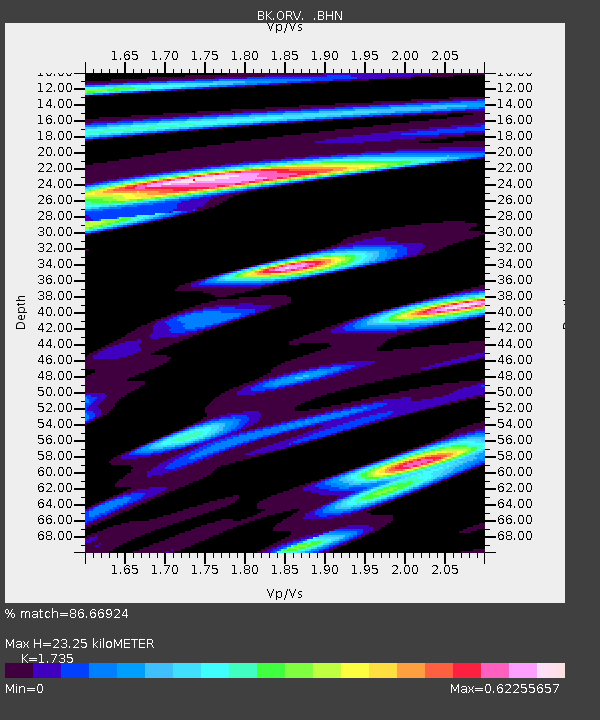
| Estimated Moho Depth: |
23.25 km |
| Estimated Crust Vp/Vs: |
1.74 |
| Assumed Crust Vp: |
6.597 km/s |
| Estimated Crust Vs: |
3.803 km/s |
| Estimated Crust Poisson's Ratio: |
0.25 |
|
| Radial Match: |
86.66924 % |
| Radial Bump: |
400 |
| Transverse Match: |
75.2908 % |
| Transverse Bump: |
400 |
| SOD ConfigId: |
2564 |
| Insert Time: |
2010-03-05 19:44:14.750 +0000 |
| GWidth: |
2.5 |
| Max Bumps: |
400 |
| Tol: |
0.001 |
|

Signal To Noise
| Channel | StoN | STA | LTA |
| BK:ORV: :BHN:20070812T12:17:13.88302Z | 2.4991488 | 8.952535E-8 | 3.5822335E-8 |
| BK:ORV: :BHE:20070812T12:17:13.88302Z | 4.4000306 | 2.3423704E-7 | 5.3235322E-8 |
| BK:ORV: :BHZ:20070812T12:17:13.88302Z | 12.721753 | 4.872801E-7 | 3.8302904E-8 |
| Arrivals |
| Ps | 2.7 SECOND |
| PpPs | 9.4 SECOND |
| PsPs/PpSs | 12 SECOND |


