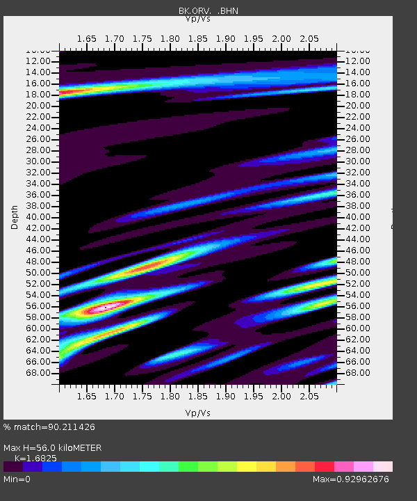
ORV Oroville Dam, CA - Earthquake Result Viewer
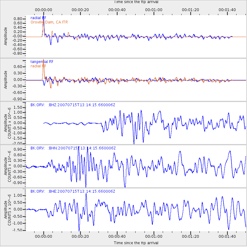
Earthquake location: Fox Islands, Aleutian Islands
Earthquake latitude/longitude: 52.5/-168.0
Earthquake time(UTC): 2007/07/15 (196) 13:08:00 GMT
Earthquake Depth: 10 km
Earthquake Magnitude: 5.8 MB, 5.9 MS, 6.1 MW, 6.0 MW
Earthquake Catalog/Contributor: WHDF/NEIC
Network: BK Berkeley Digital Seismograph Network
Station: ORV Oroville Dam, CA
Lat/Lon: 39.55 N/121.50 W
Elevation: 335 m
Distance: 34.2 deg
Az: 93.338 deg
Baz: 307.835 deg
Ray Param: 0.07785348
Estimated Moho Depth: 56.0 km
Estimated Crust Vp/Vs: 1.68
Assumed Crust Vp: 6.597 km/s
Estimated Crust Vs: 3.921 km/s
Estimated Crust Poisson's Ratio: 0.23
Radial Match: 90.211426 %
Radial Bump: 373
Transverse Match: 79.70881 %
Transverse Bump: 400
SOD ConfigId: 2564
Insert Time: 2010-03-05 19:44:34.876 +0000
GWidth: 2.5
Max Bumps: 400
Tol: 0.001

Signal To Noise

ChannelStoNSTALTA
BK:ORV: :BHN:20070715T13:14:15.660006Z3.54984261.3829987E-73.8959435E-8
BK:ORV: :BHE:20070715T13:14:15.660006Z5.09754042.4304353E-74.767859E-8
BK:ORV: :BHZ:20070715T13:14:15.660006Z6.0232173.6947563E-76.134191E-8
Arrivals
Ps6.3 SECOND
PpPs21 SECOND
PsPs/PpSs27 SECOND