You are here: Home > Network List > BK - Berkeley Digital Seismograph Network Stations List
> Station ORV Oroville Dam, CA > Earthquake Result Viewer
ORV Oroville Dam, CA - Earthquake Result Viewer
| Earthquake location: |
Near Coast Of Peru |
| Earthquake latitude/longitude: |
-15.7/-74.9 |
| Earthquake time(UTC): |
2007/06/28 (179) 08:44:48 GMT |
| Earthquake Depth: |
27 km |
| Earthquake Magnitude: |
5.5 MB, 5.3 MS, 5.8 MW, 5.8 MW |
| Earthquake Catalog/Contributor: |
WHDF/NEIC |
|
| Network: |
BK Berkeley Digital Seismograph Network |
| Station: |
ORV Oroville Dam, CA |
| Lat/Lon: |
39.55 N/121.50 W |
| Elevation: |
335 m |
|
| Distance: |
70.1 deg |
| Az: |
323.296 deg |
| Baz: |
131.871 deg |
| Ray Param: |
0.055201236 |
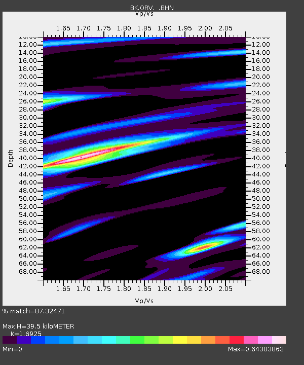
| Estimated Moho Depth: |
39.5 km |
| Estimated Crust Vp/Vs: |
1.69 |
| Assumed Crust Vp: |
6.597 km/s |
| Estimated Crust Vs: |
3.898 km/s |
| Estimated Crust Poisson's Ratio: |
0.23 |
|
| Radial Match: |
87.32471 % |
| Radial Bump: |
329 |
| Transverse Match: |
73.60475 % |
| Transverse Bump: |
396 |
| SOD ConfigId: |
2564 |
| Insert Time: |
2010-03-05 19:44:46.995 +0000 |
| GWidth: |
2.5 |
| Max Bumps: |
400 |
| Tol: |
0.001 |
|
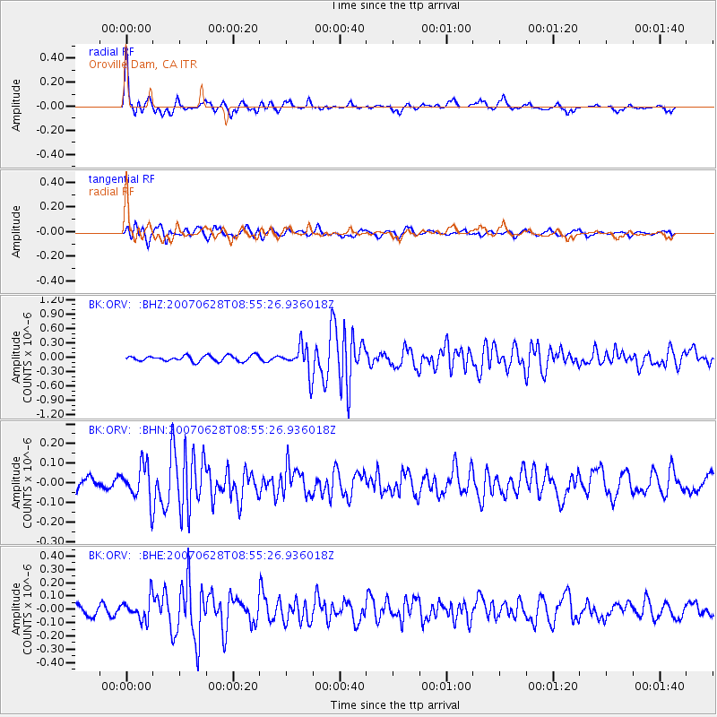
Signal To Noise
| Channel | StoN | STA | LTA |
| BK:ORV: :BHN:20070628T08:55:26.936018Z | 3.016537 | 9.24783E-8 | 3.065711E-8 |
| BK:ORV: :BHE:20070628T08:55:26.936018Z | 2.2513802 | 8.398912E-8 | 3.7305615E-8 |
| BK:ORV: :BHZ:20070628T08:55:26.936018Z | 5.0443735 | 2.954912E-7 | 5.8578372E-8 |
| Arrivals |
| Ps | 4.3 SECOND |
| PpPs | 15 SECOND |
| PsPs/PpSs | 20 SECOND |


