You are here: Home > Network List > AG - Arkansas Seismic Network Stations List
> Station CCAR Cane Creek, AR > Earthquake Result Viewer
CCAR Cane Creek, AR - Earthquake Result Viewer
| Earthquake location: |
San Juan Province, Argentina |
| Earthquake latitude/longitude: |
-31.6/-68.8 |
| Earthquake time(UTC): |
2016/11/20 (325) 20:57:43 GMT |
| Earthquake Depth: |
116 km |
| Earthquake Magnitude: |
6.4 MWP, 6.5 MWB |
| Earthquake Catalog/Contributor: |
NEIC PDE/NEIC COMCAT |
|
| Network: |
AG Arkansas Seismic Network |
| Station: |
CCAR Cane Creek, AR |
| Lat/Lon: |
33.92 N/91.77 W |
| Elevation: |
72 m |
|
| Distance: |
68.7 deg |
| Az: |
339.586 deg |
| Baz: |
159.038 deg |
| Ray Param: |
0.055816814 |
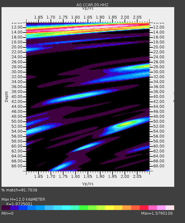
| Estimated Moho Depth: |
12.0 km |
| Estimated Crust Vp/Vs: |
1.87 |
| Assumed Crust Vp: |
6.201 km/s |
| Estimated Crust Vs: |
3.312 km/s |
| Estimated Crust Poisson's Ratio: |
0.30 |
|
| Radial Match: |
91.7836 % |
| Radial Bump: |
400 |
| Transverse Match: |
80.23429 % |
| Transverse Bump: |
400 |
| SOD ConfigId: |
11737051 |
| Insert Time: |
2019-04-26 02:48:35.892 +0000 |
| GWidth: |
2.5 |
| Max Bumps: |
400 |
| Tol: |
0.001 |
|

Signal To Noise
| Channel | StoN | STA | LTA |
| AG:CCAR:00:HHZ:20161120T21:08:04.37502Z | 22.58177 | 8.609051E-6 | 3.81239E-7 |
| AG:CCAR:00:HHN:20161120T21:08:04.37502Z | 3.6214857 | 2.4370752E-6 | 6.72949E-7 |
| AG:CCAR:00:HHE:20161120T21:08:04.37502Z | 1.6591117 | 1.2716384E-6 | 7.664574E-7 |
| Arrivals |
| Ps | 1.7 SECOND |
| PpPs | 5.4 SECOND |
| PsPs/PpSs | 7.1 SECOND |


