You are here: Home > Network List > BK - Berkeley Digital Seismograph Network Stations List
> Station ORV Oroville Dam, CA > Earthquake Result Viewer
ORV Oroville Dam, CA - Earthquake Result Viewer
| Earthquake location: |
Santiago Del Estero Prov., Arg. |
| Earthquake latitude/longitude: |
-26.0/-63.2 |
| Earthquake time(UTC): |
2006/11/13 (317) 01:26:34 GMT |
| Earthquake Depth: |
552 km |
| Earthquake Magnitude: |
6.3 MB, 6.8 MW, 6.8 MW |
| Earthquake Catalog/Contributor: |
WHDF/NEIC |
|
| Network: |
BK Berkeley Digital Seismograph Network |
| Station: |
ORV Oroville Dam, CA |
| Lat/Lon: |
39.55 N/121.50 W |
| Elevation: |
335 m |
|
| Distance: |
84.9 deg |
| Az: |
318.682 deg |
| Baz: |
129.8 deg |
| Ray Param: |
0.043560337 |
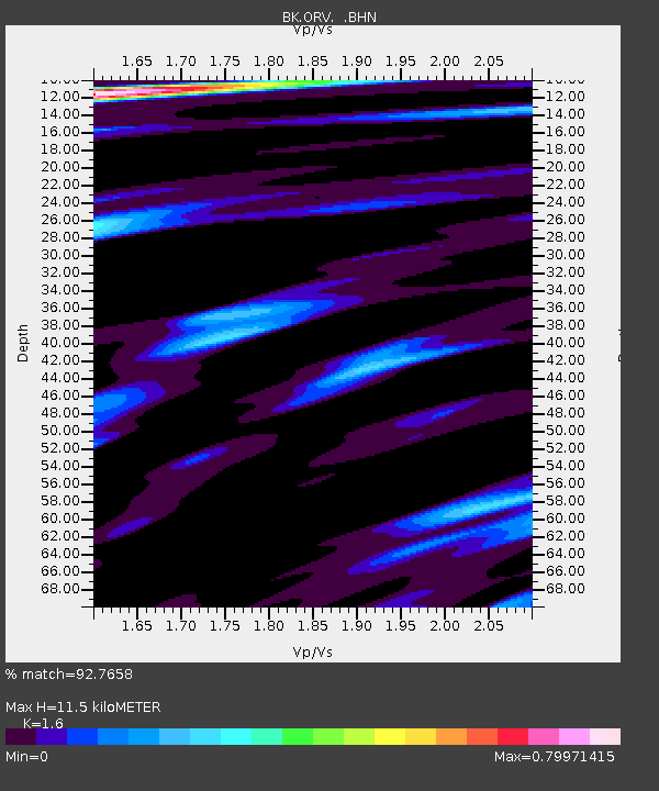
| Estimated Moho Depth: |
11.5 km |
| Estimated Crust Vp/Vs: |
1.60 |
| Assumed Crust Vp: |
6.597 km/s |
| Estimated Crust Vs: |
4.123 km/s |
| Estimated Crust Poisson's Ratio: |
0.18 |
|
| Radial Match: |
92.7658 % |
| Radial Bump: |
400 |
| Transverse Match: |
84.41176 % |
| Transverse Bump: |
400 |
| SOD ConfigId: |
2564 |
| Insert Time: |
2010-03-05 19:45:14.495 +0000 |
| GWidth: |
2.5 |
| Max Bumps: |
400 |
| Tol: |
0.001 |
|

Signal To Noise
| Channel | StoN | STA | LTA |
| BK:ORV: :BHN:20061113T01:37:39.910022Z | 1.6297517 | 4.2626968E-7 | 2.61555E-7 |
| BK:ORV: :BHE:20061113T01:37:39.910022Z | 1.0333923 | 4.0820893E-7 | 3.9501836E-7 |
| BK:ORV: :BHZ:20061113T01:37:39.910022Z | 4.0047517 | 7.37978E-7 | 1.8427559E-7 |
| Arrivals |
| Ps | 1.1 SECOND |
| PpPs | 4.4 SECOND |
| PsPs/PpSs | 5.5 SECOND |


