You are here: Home > Network List > CI - Caltech Regional Seismic Network Stations List
> Station FMP Fort MacArthur Park, Pt. Fermin San Pedro, CA, USA > Earthquake Result Viewer
FMP Fort MacArthur Park, Pt. Fermin San Pedro, CA, USA - Earthquake Result Viewer
| Earthquake location: |
San Juan Province, Argentina |
| Earthquake latitude/longitude: |
-31.6/-68.8 |
| Earthquake time(UTC): |
2016/11/20 (325) 20:57:43 GMT |
| Earthquake Depth: |
116 km |
| Earthquake Magnitude: |
6.4 MWP, 6.5 MWB |
| Earthquake Catalog/Contributor: |
NEIC PDE/NEIC COMCAT |
|
| Network: |
CI Caltech Regional Seismic Network |
| Station: |
FMP Fort MacArthur Park, Pt. Fermin San Pedro, CA, USA |
| Lat/Lon: |
33.71 N/118.29 W |
| Elevation: |
89 m |
|
| Distance: |
80.0 deg |
| Az: |
319.923 deg |
| Baz: |
138.794 deg |
| Ray Param: |
0.04828717 |
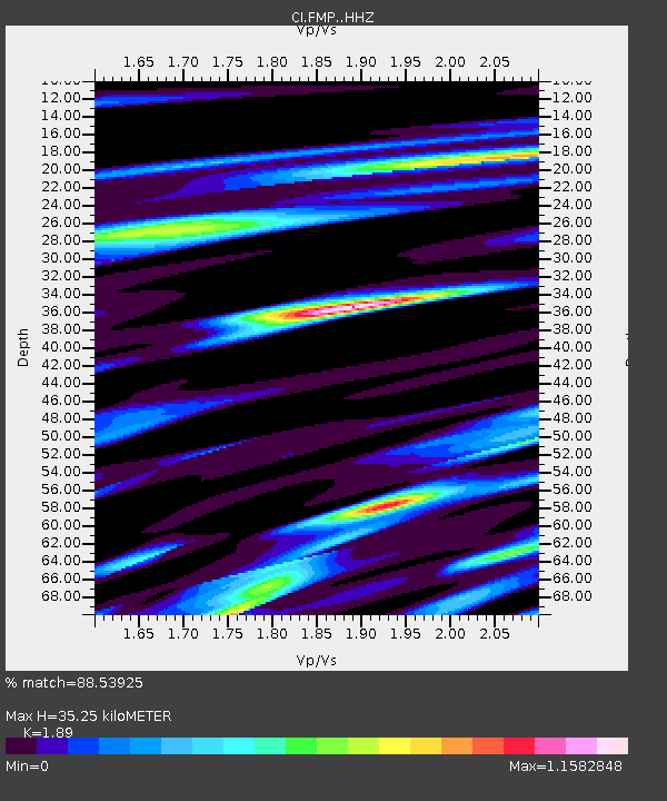
| Estimated Moho Depth: |
35.25 km |
| Estimated Crust Vp/Vs: |
1.89 |
| Assumed Crust Vp: |
6.048 km/s |
| Estimated Crust Vs: |
3.2 km/s |
| Estimated Crust Poisson's Ratio: |
0.31 |
|
| Radial Match: |
88.53925 % |
| Radial Bump: |
400 |
| Transverse Match: |
84.91773 % |
| Transverse Bump: |
400 |
| SOD ConfigId: |
11737051 |
| Insert Time: |
2019-04-26 02:49:37.161 +0000 |
| GWidth: |
2.5 |
| Max Bumps: |
400 |
| Tol: |
0.001 |
|
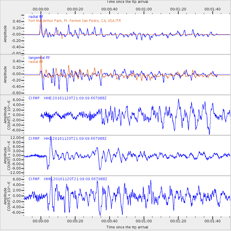
Signal To Noise
| Channel | StoN | STA | LTA |
| CI:FMP: :HHZ:20161120T21:09:09.667988Z | 6.2541156 | 3.5355265E-6 | 5.65312E-7 |
| CI:FMP: :HHN:20161120T21:09:09.667988Z | 2.2668524 | 1.5375672E-6 | 6.7828285E-7 |
| CI:FMP: :HHE:20161120T21:09:09.667988Z | 1.3995494 | 1.0348209E-6 | 7.393958E-7 |
| Arrivals |
| Ps | 5.3 SECOND |
| PpPs | 16 SECOND |
| PsPs/PpSs | 22 SECOND |


