You are here: Home > Network List > CI - Caltech Regional Seismic Network Stations List
> Station GMR Granite Mountains Research Center > Earthquake Result Viewer
GMR Granite Mountains Research Center - Earthquake Result Viewer
| Earthquake location: |
San Juan Province, Argentina |
| Earthquake latitude/longitude: |
-31.6/-68.8 |
| Earthquake time(UTC): |
2016/11/20 (325) 20:57:43 GMT |
| Earthquake Depth: |
116 km |
| Earthquake Magnitude: |
6.4 MWP, 6.5 MWB |
| Earthquake Catalog/Contributor: |
NEIC PDE/NEIC COMCAT |
|
| Network: |
CI Caltech Regional Seismic Network |
| Station: |
GMR Granite Mountains Research Center |
| Lat/Lon: |
34.78 N/115.66 W |
| Elevation: |
1326 m |
|
| Distance: |
79.4 deg |
| Az: |
322.317 deg |
| Baz: |
140.696 deg |
| Ray Param: |
0.04869084 |
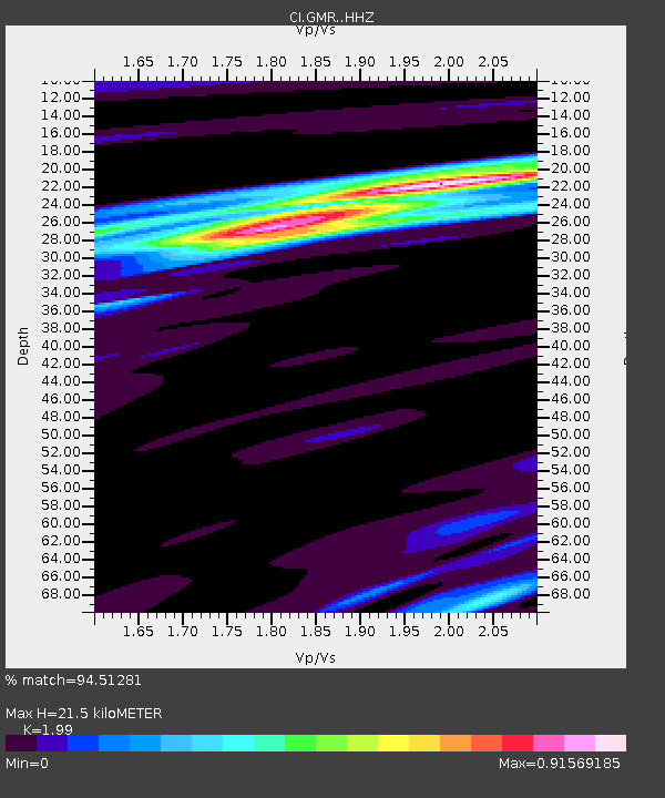
| Estimated Moho Depth: |
21.5 km |
| Estimated Crust Vp/Vs: |
1.99 |
| Assumed Crust Vp: |
6.276 km/s |
| Estimated Crust Vs: |
3.154 km/s |
| Estimated Crust Poisson's Ratio: |
0.33 |
|
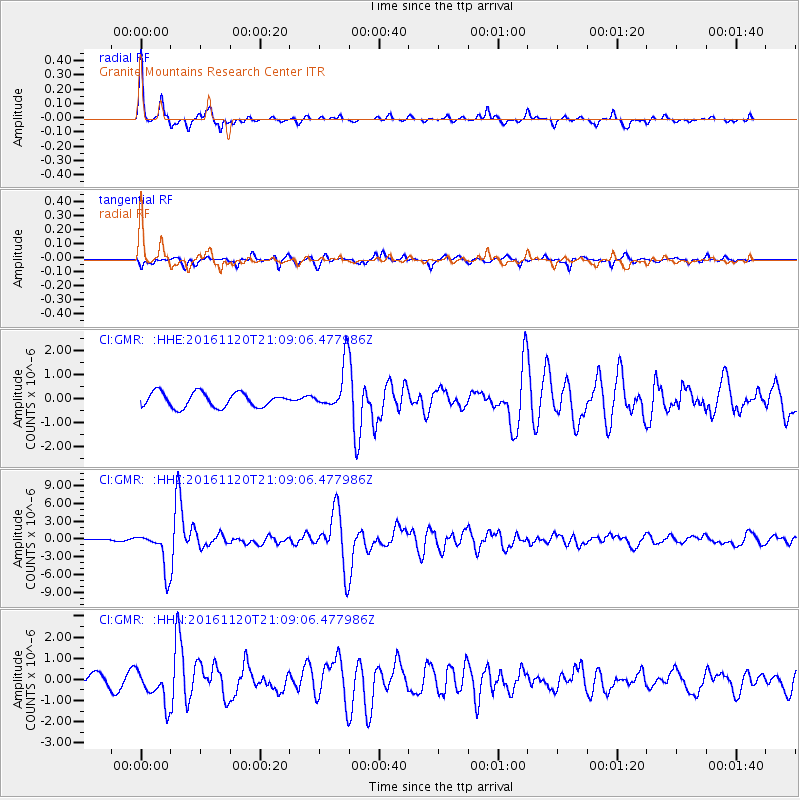
| Radial Match: |
94.51281 % |
| Radial Bump: |
294 |
| Transverse Match: |
77.726944 % |
| Transverse Bump: |
337 |
| SOD ConfigId: |
11737051 |
| Insert Time: |
2019-04-26 02:49:37.996 +0000 |
| GWidth: |
2.5 |
| Max Bumps: |
400 |
| Tol: |
0.001 |
|
Signal To Noise
| Channel | StoN | STA | LTA |
| CI:GMR: :HHZ:20161120T21:09:06.477986Z | 27.507778 | 3.3612766E-6 | 1.2219367E-7 |
| CI:GMR: :HHN:20161120T21:09:06.477986Z | 3.3193157 | 7.943152E-7 | 2.3930087E-7 |
| CI:GMR: :HHE:20161120T21:09:06.477986Z | 3.1473677 | 9.4124255E-7 | 2.9905706E-7 |
| Arrivals |
| Ps | 3.5 SECOND |
| PpPs | 10.0 SECOND |
| PsPs/PpSs | 13 SECOND |


