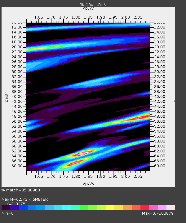
ORV Oroville Dam, CA - Earthquake Result Viewer
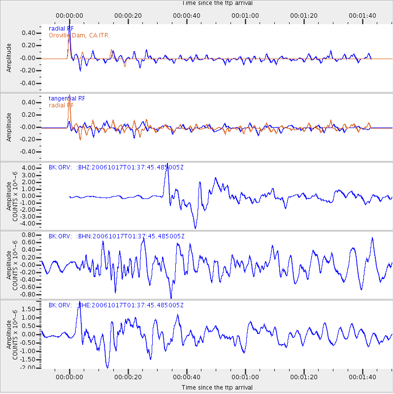
Earthquake location: New Britain Region, P.N.G.
Earthquake latitude/longitude: -5.9/151.0
Earthquake time(UTC): 2006/10/17 (290) 01:25:12 GMT
Earthquake Depth: 32 km
Earthquake Magnitude: 6.4 MB, 6.9 MS, 6.7 MW, 6.6 MW
Earthquake Catalog/Contributor: WHDF/NEIC
Network: BK Berkeley Digital Seismograph Network
Station: ORV Oroville Dam, CA
Lat/Lon: 39.55 N/121.50 W
Elevation: 335 m
Distance: 91.8 deg
Az: 50.603 deg
Baz: 263.911 deg
Ray Param: 0.04154827
Estimated Moho Depth: 62.75 km
Estimated Crust Vp/Vs: 1.83
Assumed Crust Vp: 6.597 km/s
Estimated Crust Vs: 3.61 km/s
Estimated Crust Poisson's Ratio: 0.29
Radial Match: 85.80968 %
Radial Bump: 400
Transverse Match: 88.16823 %
Transverse Bump: 400
SOD ConfigId: 2665
Insert Time: 2010-03-05 19:45:21.891 +0000
GWidth: 2.5
Max Bumps: 400
Tol: 0.001

Signal To Noise

ChannelStoNSTALTA
BK:ORV: :BHN:20061017T01:37:45.485005Z0.553753447.7409624E-81.3979079E-7
BK:ORV: :BHE:20061017T01:37:45.485005Z5.27539738.2837835E-71.5702672E-7
BK:ORV: :BHZ:20061017T01:37:45.485005Z18.0147381.9234494E-61.0677089E-7
Arrivals
Ps8.0 SECOND
PpPs26 SECOND
PsPs/PpSs34 SECOND