ORV Oroville Dam, CA - Earthquake Result Viewer
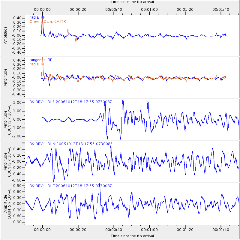
Earthquake location: Near Coast Of Central Chile
Earthquake latitude/longitude: -31.3/-71.3
Earthquake time(UTC): 2006/10/12 (285) 18:05:58 GMT
Earthquake Depth: 46 km
Earthquake Magnitude: 5.8 MB, 6.1 MS, 6.4 MW, 6.3 MW
Earthquake Catalog/Contributor: WHDF/NEIC
Network: BK Berkeley Digital Seismograph Network
Station: ORV Oroville Dam, CA
Lat/Lon: 39.55 N/121.50 W
Elevation: 335 m
Distance: 84.5 deg
Az: 323.382 deg
Baz: 138.669 deg
Ray Param: 0.04536672
Estimated Moho Depth: 38.0 km
Estimated Crust Vp/Vs: 1.76
Assumed Crust Vp: 6.597 km/s
Estimated Crust Vs: 3.738 km/s
Estimated Crust Poisson's Ratio: 0.26
Radial Match: 85.35328 %
Radial Bump: 330
Transverse Match: 65.8161 %
Transverse Bump: 400
SOD ConfigId: 2665
Insert Time: 2010-03-05 19:45:24.825 +0000
GWidth: 2.5
Max Bumps: 400
Tol: 0.001

Signal To Noise

ChannelStoNSTALTA
BK:ORV: :BHN:20061012T18:17:55.073008Z1.31927511.3784371E-71.0448443E-7
BK:ORV: :BHE:20061012T18:17:55.073008Z1.9203771.9004703E-79.896339E-8
BK:ORV: :BHZ:20061012T18:17:55.073008Z3.93233945.315773E-71.3518093E-7
Arrivals
Ps4.5 SECOND
PpPs16 SECOND
PsPs/PpSs20 SECOND