You are here: Home > Network List > CN - Canadian National Seismograph Network Stations List
> Station PAPH Port au Prince, Haiti, > Earthquake Result Viewer
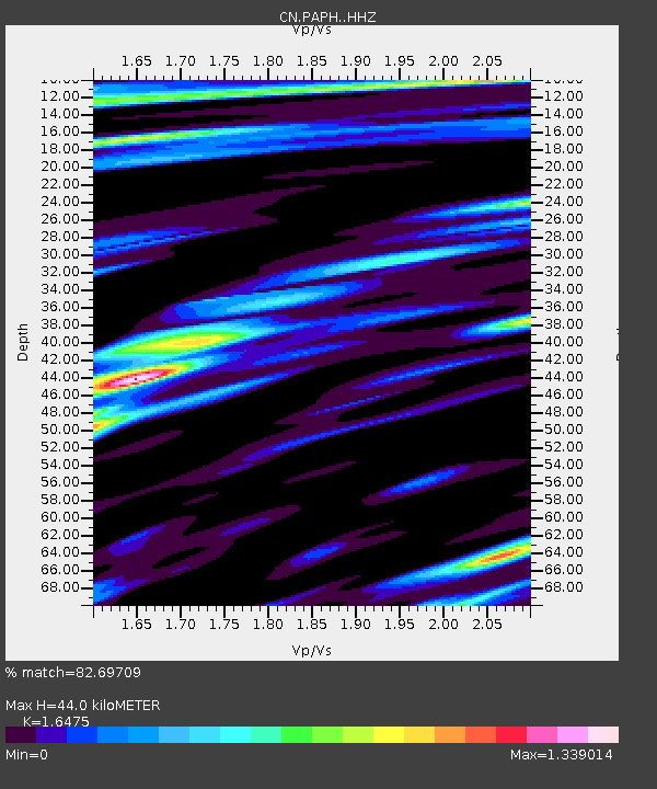
PAPH Port au Prince, Haiti, - Earthquake Result Viewer
| Earthquake location: |
San Juan Province, Argentina |
| Earthquake latitude/longitude: |
-31.6/-68.8 |
| Earthquake time(UTC): |
2016/11/20 (325) 20:57:43 GMT |
| Earthquake Depth: |
116 km |
| Earthquake Magnitude: |
6.4 MWP, 6.5 MWB |
| Earthquake Catalog/Contributor: |
NEIC PDE/NEIC COMCAT |
|
| Network: |
CN Canadian National Seismograph Network |
| Station: |
PAPH Port au Prince, Haiti, |
| Lat/Lon: |
18.52 N/72.30 W |
| Elevation: |
218 m |
|
| Distance: |
50.0 deg |
| Az: |
355.62 deg |
| Baz: |
176.063 deg |
| Ray Param: |
0.06795644 |
| Estimated Moho Depth: |
44.0 km |
| Estimated Crust Vp/Vs: |
1.65 |
| Assumed Crust Vp: |
5.14 km/s |
| Estimated Crust Vs: |
3.12 km/s |
| Estimated Crust Poisson's Ratio: |
0.21 |
|
| Radial Match: |
82.69709 % |
| Radial Bump: |
400 |
| Transverse Match: |
77.67305 % |
| Transverse Bump: |
400 |
| SOD ConfigId: |
11737051 |
| Insert Time: |
2019-04-26 02:50:38.542 +0000 |
| GWidth: |
2.5 |
| Max Bumps: |
400 |
| Tol: |
0.001 |
|

Signal To Noise
| Channel | StoN | STA | LTA |
| CN:PAPH: :HHZ:20161120T21:05:55.890004Z | 26.53931 | 7.351951E-6 | 2.7702117E-7 |
| CN:PAPH: :HHN:20161120T21:05:55.890004Z | 7.4028707 | 2.7779352E-6 | 3.7525103E-7 |
| CN:PAPH: :HHE:20161120T21:05:55.890004Z | 1.2819462 | 7.08609E-7 | 5.5276035E-7 |
| Arrivals |
| Ps | 5.8 SECOND |
| PpPs | 22 SECOND |
| PsPs/PpSs | 28 SECOND |


