You are here: Home > Network List > BK - Berkeley Digital Seismograph Network Stations List
> Station ORV Oroville Dam, CA > Earthquake Result Viewer
ORV Oroville Dam, CA - Earthquake Result Viewer
| Earthquake location: |
Near Coast Of Nicaragua |
| Earthquake latitude/longitude: |
11.5/-87.7 |
| Earthquake time(UTC): |
2004/06/10 (162) 08:59:54 GMT |
| Earthquake Depth: |
10 km |
| Earthquake Magnitude: |
5.4 MB, 5.2 MS, 5.9 MW, 5.8 MW |
| Earthquake Catalog/Contributor: |
WHDF/NEIC |
|
| Network: |
BK Berkeley Digital Seismograph Network |
| Station: |
ORV Oroville Dam, CA |
| Lat/Lon: |
39.55 N/121.50 W |
| Elevation: |
335 m |
|
| Distance: |
41.0 deg |
| Az: |
318.986 deg |
| Baz: |
123.68 deg |
| Ray Param: |
0.07405909 |
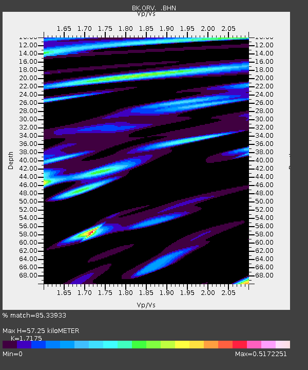
| Estimated Moho Depth: |
57.25 km |
| Estimated Crust Vp/Vs: |
1.72 |
| Assumed Crust Vp: |
6.597 km/s |
| Estimated Crust Vs: |
3.841 km/s |
| Estimated Crust Poisson's Ratio: |
0.24 |
|
| Radial Match: |
85.33933 % |
| Radial Bump: |
400 |
| Transverse Match: |
77.09346 % |
| Transverse Bump: |
400 |
| SOD ConfigId: |
124340 |
| Insert Time: |
2010-03-05 19:46:09.566 +0000 |
| GWidth: |
2.5 |
| Max Bumps: |
400 |
| Tol: |
0.001 |
|

Signal To Noise
| Channel | StoN | STA | LTA |
| BK:ORV: :BHN:20040610T09:07:06.50899Z | 2.9638803 | 2.5041325E-7 | 8.448832E-8 |
| BK:ORV: :BHE:20040610T09:07:06.50899Z | 3.4530153 | 3.1745958E-7 | 9.193692E-8 |
| BK:ORV: :BHZ:20040610T09:07:06.50899Z | 9.085267 | 6.885428E-7 | 7.578675E-8 |
| Arrivals |
| Ps | 6.7 SECOND |
| PpPs | 22 SECOND |
| PsPs/PpSs | 29 SECOND |


