You are here: Home > Network List > N4 - Central and EAstern US Network Stations List
> Station J61A Chester > Earthquake Result Viewer
J61A Chester - Earthquake Result Viewer
| Earthquake location: |
San Juan Province, Argentina |
| Earthquake latitude/longitude: |
-31.6/-68.8 |
| Earthquake time(UTC): |
2016/11/20 (325) 20:57:43 GMT |
| Earthquake Depth: |
116 km |
| Earthquake Magnitude: |
6.4 MWP, 6.5 MWB |
| Earthquake Catalog/Contributor: |
NEIC PDE/NEIC COMCAT |
|
| Network: |
N4 Central and EAstern US Network |
| Station: |
J61A Chester |
| Lat/Lon: |
43.35 N/72.55 W |
| Elevation: |
253 m |
|
| Distance: |
74.7 deg |
| Az: |
357.135 deg |
| Baz: |
176.65 deg |
| Ray Param: |
0.051875442 |
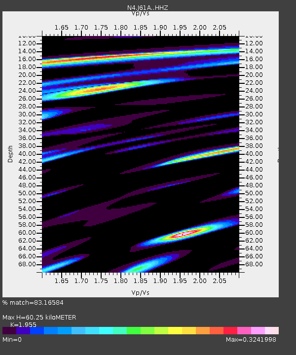
| Estimated Moho Depth: |
60.25 km |
| Estimated Crust Vp/Vs: |
1.96 |
| Assumed Crust Vp: |
6.419 km/s |
| Estimated Crust Vs: |
3.283 km/s |
| Estimated Crust Poisson's Ratio: |
0.32 |
|
| Radial Match: |
83.16584 % |
| Radial Bump: |
400 |
| Transverse Match: |
81.969376 % |
| Transverse Bump: |
400 |
| SOD ConfigId: |
11737051 |
| Insert Time: |
2019-04-26 02:53:10.379 +0000 |
| GWidth: |
2.5 |
| Max Bumps: |
400 |
| Tol: |
0.001 |
|

Signal To Noise
| Channel | StoN | STA | LTA |
| N4:J61A: :HHZ:20161120T21:08:40.079976Z | 6.886827 | 4.2968727E-6 | 6.239263E-7 |
| N4:J61A: :HHN:20161120T21:08:40.079976Z | 2.8527765 | 1.3779161E-6 | 4.8300876E-7 |
| N4:J61A: :HHE:20161120T21:08:40.079976Z | 1.4276328 | 5.331904E-7 | 3.7347868E-7 |
| Arrivals |
| Ps | 9.2 SECOND |
| PpPs | 27 SECOND |
| PsPs/PpSs | 36 SECOND |


