You are here: Home > Network List > N4 - Central and EAstern US Network Stations List
> Station K38B Parkersburg, IA, USA > Earthquake Result Viewer
K38B Parkersburg, IA, USA - Earthquake Result Viewer
| Earthquake location: |
San Juan Province, Argentina |
| Earthquake latitude/longitude: |
-31.6/-68.8 |
| Earthquake time(UTC): |
2016/11/20 (325) 20:57:43 GMT |
| Earthquake Depth: |
116 km |
| Earthquake Magnitude: |
6.4 MWP, 6.5 MWB |
| Earthquake Catalog/Contributor: |
NEIC PDE/NEIC COMCAT |
|
| Network: |
N4 Central and EAstern US Network |
| Station: |
K38B Parkersburg, IA, USA |
| Lat/Lon: |
42.65 N/92.77 W |
| Elevation: |
307 m |
|
| Distance: |
77.1 deg |
| Az: |
342.069 deg |
| Baz: |
159.151 deg |
| Ray Param: |
0.050244946 |
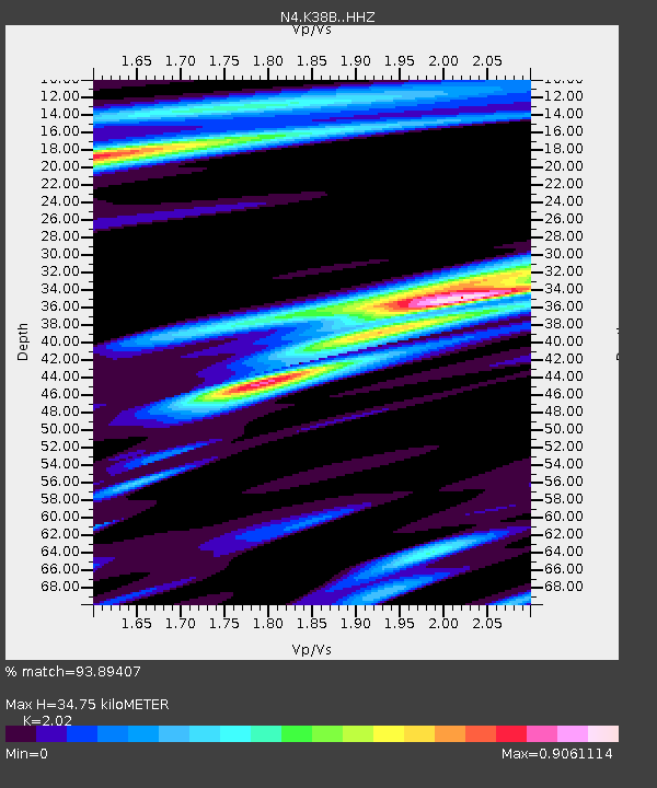
| Estimated Moho Depth: |
34.75 km |
| Estimated Crust Vp/Vs: |
2.02 |
| Assumed Crust Vp: |
6.53 km/s |
| Estimated Crust Vs: |
3.233 km/s |
| Estimated Crust Poisson's Ratio: |
0.34 |
|
| Radial Match: |
93.89407 % |
| Radial Bump: |
400 |
| Transverse Match: |
81.861855 % |
| Transverse Bump: |
400 |
| SOD ConfigId: |
11737051 |
| Insert Time: |
2019-04-26 02:53:11.364 +0000 |
| GWidth: |
2.5 |
| Max Bumps: |
400 |
| Tol: |
0.001 |
|

Signal To Noise
| Channel | StoN | STA | LTA |
| N4:K38B: :HHZ:20161120T21:08:53.889973Z | 23.848251 | 6.925345E-6 | 2.9039217E-7 |
| N4:K38B: :HHN:20161120T21:08:53.889973Z | 6.861243 | 2.5077609E-6 | 3.6549662E-7 |
| N4:K38B: :HHE:20161120T21:08:53.889973Z | 2.1641366 | 7.907133E-7 | 3.6537122E-7 |
| Arrivals |
| Ps | 5.6 SECOND |
| PpPs | 16 SECOND |
| PsPs/PpSs | 21 SECOND |


