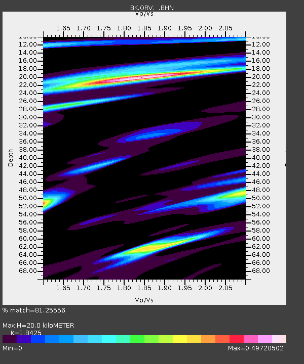
ORV Oroville Dam, CA - Earthquake Result Viewer

Earthquake location: Southeast Of Loyalty Islands
Earthquake latitude/longitude: -22.0/170.3
Earthquake time(UTC): 2004/05/07 (128) 01:26:42 GMT
Earthquake Depth: 14 km
Earthquake Magnitude: 5.7 MB, 6.2 MS, 6.3 MW, 6.2 MW
Earthquake Catalog/Contributor: WHDF/NEIC
Network: BK Berkeley Digital Seismograph Network
Station: ORV Oroville Dam, CA
Lat/Lon: 39.55 N/121.50 W
Elevation: 335 m
Distance: 88.3 deg
Az: 45.912 deg
Baz: 239.575 deg
Ray Param: 0.04270045
Estimated Moho Depth: 20.0 km
Estimated Crust Vp/Vs: 1.84
Assumed Crust Vp: 6.597 km/s
Estimated Crust Vs: 3.581 km/s
Estimated Crust Poisson's Ratio: 0.29
Radial Match: 81.25556 %
Radial Bump: 288
Transverse Match: 75.36144 %
Transverse Bump: 400
SOD ConfigId: 2459
Insert Time: 2010-03-05 19:46:12.657 +0000
GWidth: 2.5
Max Bumps: 400
Tol: 0.001

Signal To Noise

ChannelStoNSTALTA
BK:ORV: :BHN:20040507T01:39:01.483997Z3.15860221.4967429E-74.7386244E-8
BK:ORV: :BHE:20040507T01:39:01.483997Z3.0782722.4791862E-78.0538236E-8
BK:ORV: :BHZ:20040507T01:39:01.483997Z6.1760618.030415E-71.3002486E-7
Arrivals
Ps2.6 SECOND
PpPs8.4 SECOND
PsPs/PpSs11 SECOND