You are here: Home > Network List > BK - Berkeley Digital Seismograph Network Stations List
> Station ORV Oroville Dam, CA > Earthquake Result Viewer
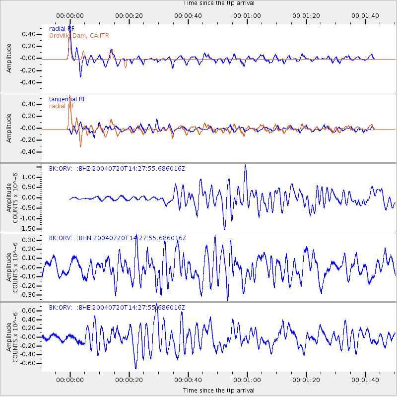
ORV Oroville Dam, CA - Earthquake Result Viewer

| Earthquake location: |
Mariana Islands Region |
| Earthquake latitude/longitude: |
19.6/146.8 |
| Earthquake time(UTC): |
2004/07/20 (202) 14:16:23 GMT |
| Earthquake Depth: |
13 km |
| Earthquake Magnitude: |
5.7 MB, 5.6 MS, 5.9 MW, 5.9 MW |
| Earthquake Catalog/Contributor: |
WHDF/NEIC |
|
| Network: |
BK Berkeley Digital Seismograph Network |
| Station: |
ORV Oroville Dam, CA |
| Lat/Lon: |
39.55 N/121.50 W |
| Elevation: |
335 m |
|
| Distance: |
79.0 deg |
| Az: |
51.922 deg |
| Baz: |
286.325 deg |
| Ray Param: |
0.0492382 |
| Estimated Moho Depth: |
26.0 km |
| Estimated Crust Vp/Vs: |
1.60 |
| Assumed Crust Vp: |
6.597 km/s |
| Estimated Crust Vs: |
4.123 km/s |
| Estimated Crust Poisson's Ratio: |
0.18 |
|
| Radial Match: |
90.21373 % |
| Radial Bump: |
335 |
| Transverse Match: |
77.15676 % |
| Transverse Bump: |
400 |
| SOD ConfigId: |
124340 |
| Insert Time: |
2010-03-05 19:46:19.445 +0000 |
| GWidth: |
2.5 |
| Max Bumps: |
400 |
| Tol: |
0.001 |
|
Signal To Noise
| Channel | StoN | STA | LTA |
| BK:ORV: :BHN:20040720T14:27:55.686016Z | 1.0629874 | 7.9743856E-8 | 7.5018626E-8 |
| BK:ORV: :BHE:20040720T14:27:55.686016Z | 1.7850058 | 8.4756486E-8 | 4.7482473E-8 |
| BK:ORV: :BHZ:20040720T14:27:55.686016Z | 2.4941177 | 1.6241925E-7 | 6.512093E-8 |
| Arrivals |
| Ps | 2.4 SECOND |
| PpPs | 9.9 SECOND |
| PsPs/PpSs | 12 SECOND |


