You are here: Home > Network List > GS - US Geological Survey Networks Stations List
> Station KAN13 Rinehart Farm, , CA, USA > Earthquake Result Viewer
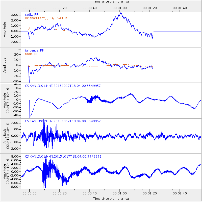
KAN13 Rinehart Farm, , CA, USA - Earthquake Result Viewer
*The percent match for this event was below the threshold and hence no stack was calculated.
| Earthquake location: |
West Chile Rise |
| Earthquake latitude/longitude: |
-42.6/-82.4 |
| Earthquake time(UTC): |
2015/10/17 (290) 17:52:20 GMT |
| Earthquake Depth: |
11 km |
| Earthquake Magnitude: |
5.6 MWW, 5.6 MWB, 5.6 MWC |
| Earthquake Catalog/Contributor: |
NEIC PDE/NEIC COMCAT |
|
| Network: |
GS US Geological Survey Networks |
| Station: |
KAN13 Rinehart Farm, , CA, USA |
| Lat/Lon: |
37.01 N/97.48 W |
| Elevation: |
340 m |
|
| Distance: |
80.4 deg |
| Az: |
347.85 deg |
| Baz: |
168.81 deg |
| Ray Param: |
$rayparam |
*The percent match for this event was below the threshold and hence was not used in the summary stack. |
|
| Radial Match: |
28.67215 % |
| Radial Bump: |
400 |
| Transverse Match: |
61.33433 % |
| Transverse Bump: |
400 |
| SOD ConfigId: |
1259291 |
| Insert Time: |
2015-10-31 18:09:22.615 +0000 |
| GWidth: |
2.5 |
| Max Bumps: |
400 |
| Tol: |
0.001 |
|
Signal To Noise
| Channel | StoN | STA | LTA |
| GS:KAN13:01:HHZ:20151017T18:04:00.554995Z | 1.8338854 | 4.6563846E-7 | 2.5390815E-7 |
| GS:KAN13:01:HHN:20151017T18:04:00.554995Z | 0.31668726 | 1.2847943E-6 | 4.056981E-6 |
| GS:KAN13:01:HHE:20151017T18:04:00.554995Z | 1.4760801 | 1.7077722E-5 | 1.1569645E-5 |
| Arrivals |
| Ps | |
| PpPs | |
| PsPs/PpSs | |


